Lusatia
The areas east and west along the Spree in the German part of Lusatia are home to the Slavic Sorbs, one of Germany’s four officially recognized indigenous ethnic minorities.
The Tropical Islands Resort, a large water park housed in a former airship hangar that is the biggest free-standing hall in the world, is located in the north of Lusatia.
Lusatia comprises two both scenically and historically different parts: a hilly southern "upper" section and a "lower" region, which belongs to the North European Plain.
The border between Upper and Lower Lusatia is roughly marked by the course of the Black Elster river at Senftenberg and its eastern continuation toward the Silesian town of Przewóz on the Lusatian Neisse.
Upper Lusatia is characterized by fertile soil and undulating hills as well as by historic towns and cities such as Bautzen, Görlitz, Zittau, Löbau, Kamenz, Lubań, Bischofswerda, Herrnhut, Hoyerswerda, and Bad Muskau.
Many villages in the very south of Upper Lusatia contain a typical attraction of the region, the so-called Umgebindehäuser, half-timbered-houses representing a combination of Franconian and Slavic style.
Among those villages are Niedercunnersdorf, Obercunnersdorf, Wehrsdorf, Jonsdorf, Sohland an der Spree with Taubenheim, Oppach, Varnsdorf or Ebersbach.
Most of the area belonging to the German state of Brandenburg today is called Lower Lusatia (Niederlausitz, Łużyce Dolne or Dolna Łužyca) and is characterized by forests and meadows.
Important towns include Cottbus, Eisenhüttenstadt, Lübben, Lübbenau, Spremberg, Finsterwalde, Senftenberg (Zły Komorow), and Żary, which is now considered the capital of Polish Lusatia.
[1] Between Upper and Lower Lusatia is a region called the Grenzwall, literally meaning "border dyke", although it is in fact a morainic ridge.
In the Middle Ages this area had dense forests, so it represented a major obstacle to civilian and military traffic.
They arose from faults in the terminal moraine of glaciers from the Ice Age, and partly through the mining of soil raw materials such as sand, clay and coal even before industrialization.
Due to oxidation and the associated loss of volume in the areas near the surface of the brown coal seams, furrows of 3 m to 5 m, a maximum of 20 m deep, 10 m to 30 m wide and up to several kilometers long were formed.
Known as "Gieser" (from the Sorbian "jězor" for "lake"), they form long stretches of drainless ditches that are either filled with standing water or often peat-covered.
The later Upper Lusatian region of the Milceni lands up to the Silesian border at the Kwisa river at first was part of the Margraviate of Meissen under Margrave Eckard I.
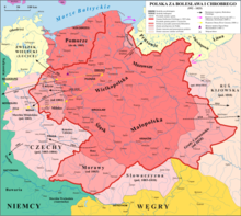
At the same time the Polan duke of the later Kingdom of Poland raised claims to the Lusatian lands and upon the death of Emperor Otto III in 1002, Margrave Gero II lost Lusatia to the Polish Duke Boleslaw I the Brave, who took the region in his conquests, acknowledged by Henry II first in the same year in Merseburg and later in the 1018 Peace of Bautzen, Lusatia became part of his territory; however, Germans and Poles continued to struggle over the administration of the region.
It was regained in a 1031 campaign by Emperor Conrad II in favour of the Saxon German rulers of the Meissen House of Wettin and the Ascanian margraves of Brandenburg, who purchased the March of (Lower) Lusatia in 1303.
In 1367 the Brandenburg elector Otto V of Wittelsbach finally sold Lower Lusatia to King Karel of Bohemia, thereby becoming a Bohemian crown land.
The cities were represented in the (Upper) Lusatian Landtag assembly, where they met with the fierce opposition of the noble state countries.
One of the main escape routes for insurgents of the unsuccessful Polish November Uprising from partitioned Poland to the Great Emigration led through Lübben and Luckau.
During World War II, some Sorbian activists were arrested, executed, exiled or sent as political prisoners to concentration camps.
[16] The Eastern Front reached Lusatia in early 1945, with Soviet and Polish troops defeating the Germans and capturing the region.
[17] After World War II according to the Potsdam Agreement, Lusatia was divided between Allied-occupied Germany (Soviet occupation zone) and the Republic of Poland along the Oder–Neisse line.
Poland's communist government expelled all remaining Germans and Sorbs from the area east of the Neisse river in 1945 and 1946 in accordance with the Potsdam Agreement.
Between 1945 and 1947 they produced about ten memorials[18] to the United States, Soviet Union, Great Britain, France, Poland, and Czechoslovakia; however, this did not bring any results.
On 30 April 1946, the Lusatian National Committee also submitted a petition to the Polish Government, signed by Paweł Cyż – the minister and an official Sorbian delegate in Poland.
Lusatian schools and magazines were launched and the Domowina association was revived, although under increasing political control of the ruling Communist Socialist Unity Party of Germany (SED).
The coal industry in the region (like the Schwarze Pumpe power station needing vast areas of land) destroyed dozens of Lusatian villages in the past and threatens some of them even now.
Some Sorbian dishes like boiled potatoes with linseed oil and curd (German: Quark mit Leineöl)[19] are still prevalent and, today, are eaten in other parts of Germany (like Berlin or western Saxony) too.
Percentage of Sorbs: Total number: 93,032[21] The percentage of Serbs (Sorbs) in Lusatia has decreased since the 1900 census due to intermarriage, germanization, cultural assimilation related to industrialization and urbanization, Nazi suppression and discrimination, ethnocide and the settlement of expelled Germans after World War II, mainly from Lower Silesia and northern Bohemia.