Lycian Way
The Lycian Way (Turkish: Likya Yolu) is a marked long-distance hiking trail in southwestern Turkey around part of the coast of ancient Lycia.
[2] Lycia was a region on the Western Taurus Mountains in Teke Peninsula at southwestern Anatolia on the Mediterranean Sea coast, located in what are today the provinces of Muğla and Antalya.
They built city-states along the Mediterranean Sea coast, such as Xanthos, Patara, Myra, Pinara, Tlos, Olympos, and Phaselis, and formed the Lycian League.
The long-distance trail is waymarked after the French Grande Randonnée special system, and the intersections are marked with yellow directional signs.
[5] Clow wrote a guidebook[3] in which the characteristics of the trail, such as the width of the path, the kinds of waymarks, and the distance and hiking time of the stages, are described.
[4] The region has hot, dry summers and mild winters with low annual rainfall due to the prevailing Mediterranean climate.
[5] Other useful equipment includes compass, trail map, whistle, pocket knife, headlight, camera, lighter, spare battery, a small first-aid kit, and a mobile phone.
[5] The first Lycian Way had the following stages Hisarönü (Ovacık)-Faralya, Faralya-Kabak Bay, Kabak Bay-Alınca, Alınca-Yediburunlar, Yediburunlar-Gavurağılı, Gavurağılı-Patara, Patara-Kalkan, Kalkan-Sarıbelen-Gökçeören, Gökçeören-Kaş, Kaş-Kekova, Kekova-Demre, Demre-Alakilise-Finike, Karaöz-Cape Gelidonya-Adrasan, Adrasan-Olimpos-Çıralı, Çıralı-Beycik, Çıralı-Tekirova, Tekirova-Phaselis-Gedelme, Beycik-Tahtalı Dağı-Gedelme, Gedelme-Göynük, Göynük-Hisarçandır, and Hisarçandır-Geyikbayırı.
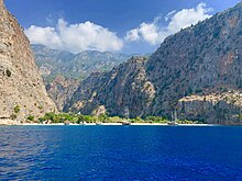
[5] The trail splits into:[6] Places of interest along the trail include: Ölüdeniz, Butterfly Valley, Faralya, Kabak Bay, Cennet Bay, Korsan Bay, Letoon (historical capital of the Lycian region, a UNESCO World Heritage Site in Seydikemer), Sidyma, Bel, Gavurağılı, Letoon, Kınık (Xanthos), Akbel, Gelemiş village and ruins of Patara (the Lycian capital), Kalkan, Sarıbelen, Gökçeören, Kaş (Antiphellos), Üçağız, Kale, Demre (Myra), Kumluca, Belören, Zeytin and Alakilise, İncegeriş Hill (1,811 m (5,942 ft) AMSL), Belos, Finike, Kumluca, Mavikent, Karaöz, the lighthouse of Cape Gelidonya (the southernmost point of Lycia), Adrasan, Olympos, Çıralı and Yanartaş (Chimaera).
[2][5] Lodging is offered in hotels, motels, and bed and breakfast suitable for all budgets in locations[2] such as Fethiye, Ölüdeniz, Faralya, Kabak Bay, Patara, Kalkan, Kaş, Kekova, Demre, Finike, Adrasan, Olympos, Çıralı, Tekirova, Çamyuva, Kemer, and Göynük.
Campsites in Kabak Bay, Patara, Özlen Çay, Sıcak Adası, Andriake (Çayağzı Port), Olympos, Çıralı, and Göynük are recommended.