M1 road (Malawi)
As the longest road in Malawi, the M1 plays a role in connecting the country's major urban centers and facilitating trade and travel.
While the connection to Mozambique was less significant at the time, historical maps from the 1950s reveal that the route briefly strayed into Mozambican territory between Dedza and Ntcheu, before returning to Malawian soil.
The colonial-era infrastructure laid the foundation for the modern M1 road, which continues to play a crucial role in Malawi's transportation network.
The road then follows a lengthy lakeside route to Chiweta, where it turns inland and begins a steep ascent, climbing from 500 to 1,100 meters in altitude.
As it approaches Jenda, the road hugs the border with Zambia, then passes through Kasungu and Mponela before reaching the capital city of Lilongwe.
As it approaches the Mozambican border, the road passes through the towns of Dedza and Ntcheu, descending gradually to an altitude of approximately 500 meters in southern Malawi.
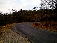
In the city center, the M2 road diverges, and the M1 continues southeast, passing through a mountain range and descending via a winding route to the River Shire.
From there, the road follows the river's course at an elevation of less than 100 meters above sea level, traversing the southern tip of Malawi, which is flanked by Mozambique on two sides.
Finally, the M1 reaches the provisional border crossing at Marka, where it connects with Mozambique's N300 road, leading to Villa de Senna.