MAX Blue Line
The Blue Line is the longest in the network; it travels approximately 33 miles (53 km) and serves 48 stations from Hatfield Government Center to Cleveland Avenue.
[17][18] That same year, an anti-freeway group called Sensible Transportation Options for People (STOP) was formed, while Neil Goldschmidt ran a successful election campaign on freeway opposition to become a member of the Portland City Council and eventually, mayor.
[20][22][23] In 1973, a separate EIS prepared by Skidmore, Owings & Merrill determined that if built, the Mount Hood Freeway would only add more traffic to downtown Portland than the surface streets could handle.
[13][24] Then, on February 4, 1974, U.S. District Judge James M. Burns rejected the freeway plan after finding that the corridor selection process failed to follow the appropriate procedures.
[37][38] Among five alternatives developed by the Highway Division, including the removal or extension of an existing high-occupancy vehicle lane,[39] a busway had been favored for the Banfield Corridor.
[1][41] Notable opposition came from the East County Concerned Citizens; 5,400 individuals signed a petition against any alternative involving light rail for costs and lack of presumed ridership.
[53]: 13 [54] From Ruby Junction to Cleveland Avenue, planners assumed acquisition of a two-mile (3.2 km) section owned by the Portland Traction Company (PTC).
[55] In August 1983, PTC agreed to surrender this segment as part of a longer abandonment up to Linnemann Junction,[56] a total of 4.3 miles (6.9 km) of right-of-way, which TriMet bought for $2.9 million in December of that year.
[61][62] Light rail construction, which progressed largely east to west, commenced the following year in April, on the two-mile (3.2 km) section between Ruby Junction and Cleveland Avenue.
[71] This included the validation of the new light rail cars, which initially encountered electrical braking glitches, by putting each of them through 1,500 miles (2,400 km) of on-track testing.
[73] On July 28, 1986, an eastbound car conducting a test run struck and killed a man who had trespassed onto the light rail tracks near Northeast 68th Avenue.
MAX cars were equipped with stop-request bell cords (as are commonly found on American transit buses), which passengers needed to pull to signal the operator that they wanted to get off at the next stop.
In early 1996, a second track was laid and a second platform was constructed at Gresham Central Transit Center,[88] making the section double-track and eliminating the only remaining single-track on the Eastside MAX.
[89] The new track was brought into use in May after a three-month suspension of MAX service east of Rockwood/East 188th Avenue station;[88] it had been replaced by shuttle buses to allow the work to be carried out.
[91] After operating for 30 years, these stations closed permanently in March 2020, owing to low ridership and to speed up train travel times across the city center.
[100]: 3–32 In 1979, plans to restore passenger rail service from Portland to the west side emerged with a proposal to extend MAX to 185th Avenue, near the Hillsboro–Beaverton boundary.
[101]: 2 [100]: 2–1 In 1983, Metro (the successor to CRAG) selected light rail as the preferred mode alternative, and the Urban Mass Transportation Administration (UMTA) released $1.3 million to begin a preliminary engineering study.
[103] The project was later suspended by TriMet amid conflict with UMTA, who wanted the former to develop a financing plan before it released funding for preliminary engineering work.
[104][102] By the time planning resumed in January 1988,[105] significant changes in the Westside Corridor, including the conversion of 3,000 acres (1,214 ha) of vacant Washington County land into mixed-use urban areas, required a re-evaluation that was completed in May 1991.
[110] Funding for the westside extension proved difficult to obtain under the Reagan Administration, which sought to reduce federal expenditures by delaying existing light rail projects and declining to approve future planning.
Senator Mark Hatfield and U.S. Representative Les AuCoin secured preliminary engineering and environmental review grants in 1989 by withholding funds from the head of UMTA's office.
[117][118] In 1990, Congress adopted legislation requiring the federal government to cover a 75 percent share of transit projects approved within the fiscal year.
[122][123] The Federal Transit Administration (the new name for UMTA) completed the funding package in 1991, granting $515 million to build the line up to 185th Avenue.
[133] Initially planned to run alongside freight trains through Beaverton and Hillsboro, the alignment was replaced with light rail following TriMet's acquisition of the BN right-of-way in June.
[142][143] On August 31, 1997, the Westside MAX opened its first section, a two-station extension west to the Civic Stadium and Kings Hill/SW Salmon Street,[144] in conjunction with the entry into service of the first low-floor cars.
[131] Ceremonies were held at various stations and speeches were delivered by local and national dignitaries, including Vice President Al Gore.
The study identified a best route option using existing tracks between Southwest Adams Avenue in Hillsboro and Douglas Street in Forest Grove.
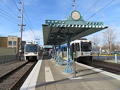
[156][157][a] Its western terminus is Hatfield Government Center in Hillsboro, on the corner of West Main Street and Southwest Adams Avenue.
[162] The tracks reconnect on Southwest 1st Avenue and head north, traversing the Willamette River via the Steel Bridge into the Rose Quarter.
[80][184] In June 1987, TriMet's general manager, James Cowen, claimed MAX ridership had grown to a point where it was "a peak all day" with a farebox recovery ratio of 50 percent.