MacLehose Trail
The first step towards the creation of country parks was the approval of a $33 million, five-year plan for "recreational development" in 1972,[1] which included the provisioning of equipment such as picnic tables, litter bins, and barbeque pits.
The Director of Agriculture and Fisheries, E. H. "Ted" Nichols, announced in July 1975 that the Government planned on passing legislation to give country parks statutory status.
[9] Numerous attempts have been made since then; the record as of May 2021[update] of 10 hours, 38 minutes, 8 seconds was set by Wong Ho-Chung, one of Hong Kong's best ultramarathon runners, on 4 December 2020.
[11] In 2018, a mainland Chinese man was sentenced to seven years' imprisonment for serial robbery on hiking paths, including the MacLehose Trail at Ma On Shan.
[13] The MacLehose Trail celebrated its 40th anniversary on 26 October 2019, with the Agriculture, Fisheries and Conservation Department (AFCD) holding celebratory events in Shing Mun Country Park, through which Sections 6 and 7 run.
[14] Events included treetop ropes courses, a hiking challenge up Needle Hill, guided war relic tours, and children's free play activities.
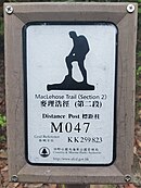
The most prominent feature is arguably the distinctive logo for the MacLehose Trail: the silhouette of a young backpacker with one leg on a rock, hands resting on their knee, facing towards the left.
[20] Lord MacLehose commented that the logo "immortalise[d him] as the perpetrator of intense fatigue in exhausted bodies under heavy loads on semi-perpendicular slopes",[21] but others have described it as "aesthetically beautiful".
About 4km from the start, the trail crosses the western dam of the reservoir, providing an expansive view over Kau Sai Chau, Chong Hing Water Sports Centre and Yuet Ming Pavilion.
[28] The trail leaves High Island onto the East Dam, where visitors are able to view hexagonal columnar jointing of volcanic tuff, an integral part of the UNESCO Global Geopark.
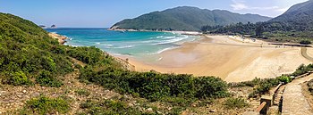
[34] Veering right at Chui Tung Au, the main trail reaches sea level at Sai Wan Beach, a popular campsite with toilet facilities and small stores.
The trail climbs a small hill to reach Tai Long Au and crosses the Sai Kung/Tai Po administrative border, before descending westwards to sea level at Chek Keng, where kai-to services to Wong Shek and Wan Tsai are available.
[40] The MacLehose Trail continues southwards through the uplands of the Sai Kung peninsula, passing Wa Mei Shan and Lui Ta Shek.
The view from the peak provides a 360-degree panorama over Three Fathoms Cove, Yim Tin Tsai, and other mountains in the Sai Kung West Country Park.
Skirting past Pyramid Hill, the path opens up onto the Ngong Ping plateau, offering expansive views over Sai Kung Town and Port Shelter.
From here, the MacLehose Trail roughly forms the administrative boundary between Sha Tin and Sai Kung, proceeding southwards towards Buffalo Pass while commanding a view over Hebe Haven and the Hong Kong Marina.
[50] Section 5 starts by briefly following the Gilwell Camp access road northbound, then sharply swerves left to lead onto a mountain trail, skirting Tate's Cairn.
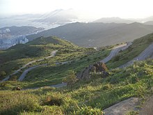
The path then joins Fei Ngo Shan Road near Jat's Incline Viewpoint, which provides panoramic views over urban Kowloon, Hong Kong Island, Victoria Harbour, Lei Yue Mun, and the old Kai Tak Airport.
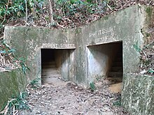
[59] The MacLehose Trail continues northwards onto Smuggler's Ridge — an area full of historic relics and monuments from the Battle of Hong Kong, the most prominent of which is the remnants of the Gin Drinkers' Line.
[60] The tunnels of the Shing Mun Redoubt, an integral part of the Gin Drinkers' Line, still stand in good condition,[61] bearing the names of major London thoroughfares such as Shaftesbury Avenue and Regent Street.
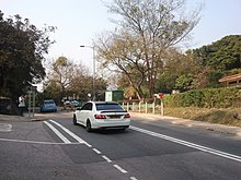
[64] Hikers can leave the MacLehose Trail by turning left at Shing Mun Road and walking approximately 2 km to Lei Muk Shue, where public transport is available.
[69] The trail continues northwards on a descent equally as steep as the preceding ascent, and joins the paved Shing Mun Forest Track near distance post M130.
[70] Branching off into the forest, the trail descends westward towards Lead Mine Pass, where Section 7 ends[68] — there is an official campsite close by, complete with barbeque pits and flushing toilets.
[72] Tai Mo Shan is the coldest place in Hong Kong, attracting visitors wanting to catch a glimpse of frost during cold spells.
[75] Tai Mo Shan also receives more than 30% more rainfall than urban Hong Kong, and acts as the source for both the Lam Tsuen and Shing Mun rivers.
[76] Until October 2009, the trail ran along the full length of the road to the junction with Route Twisk, but now diverges mid-way onto a dirt path in a bid to segregate vehicular and pedestrian traffic.
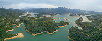
Situated in a deep valley, Ho Pui Reservoir serves as an important source of water for agriculture in the northwestern New Territories, and was voted one of the top ten attractions of Hong Kong.
[83] At the foot of the mountains are the rural communities of Shek Kong, Kam Tin, and Pat Heung, the idyllic scenery of which hikers can enjoy from the MacLehose Trail.
[84] The trail eventually descends from the mountain ridge and meanders through the woodland, before terminating at Tin Fu Tsai, two kilometres away from Tai Lam Chung Reservoir.
The endpoint of the full MacLehose Trail is under a Light Rail overpass near Pui To stop, at the end of a descent from the catchwater — an example of the contrasts between Hong Kong's countryside and urban areas.