Macquarie triple junction
Our understanding of the evolution of the Macquarie triple junction was made possible due to extensive research of the regions tectonic magnetic anomalies as well as local fractures reconstruction.
[5] This large offset in the Southeast Indian Ridge is thought to have produced a significant difference in crustal thickness within the Australian plate influencing the Hjort Trench formation.
[10] The understanding of the Macquarie triple junction is primarily due to the study of the seismicity, gravitational, magnetic and bathymetric data of the region.
Initial studies took place during the early 1970s by the Eltanin Cruises, which took bathymetric and magnetic tracks in order to interpret the general sea floor topography and sea-floor spreading rates.
[6] From analysis of the data obtained from the OGS-Explora, a major change in the Pacific-Antarctic plate motion has been interpreted, instigating the compressional region of the Macquarie Ridge.
High-resolution bathymetric and magnetic data were acquired by R/V Araon and M/V L’Astrolabe cruises along the axis of the two easternmost Southeast Indian Ridge segments which by 2017 had confirmed the recent existence of a Macquire microplate.
[1] In 2017 and 2019 R/V Explora and R/V Laura Bassi undertook multibeam and magnetic surveys focused on the three plate boundaries meeting at the Macquarie triple junction.
[11] The Amsterdam-St. Paul Plateau along with the Southeast Indian Ridge produce new oceanic crust further separating the Indo-Australian and Antarctic plates at an intermediate tectonic rate of 65 mm/yr.
The PAR is divergent boundary[13] driven by the interaction of a MOR and deep mantle plumes[14] located in the eastern portion of the East Pacific Rise.
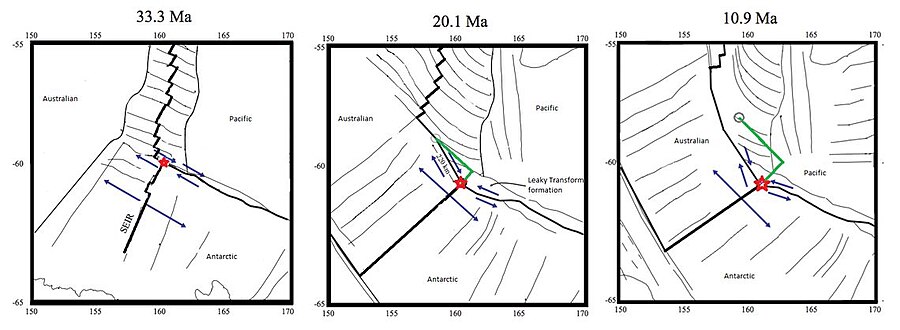
There is increasing evidence that the last 6.4 million years of this evolution at the triple junction has been associated with the creation of a separate microplate, the Macquarie plate.
The Puysegur Trench ranges approximately 800 kilometers in length, from the most southern tip of the New Zealand Islands to the Macquarie triple junction.