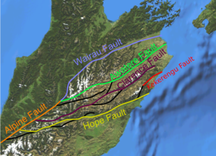
Alpine Fault
In the middle, the Alpine Fault is a transform boundary and has both dextral (right-lateral) strike-slip movement and uplift on the southeastern side.
[2] The uplift is due to an element of convergence between the plates, meaning that the fault has a significant high-angle reverse oblique component to its displacement.
[b] The Alpine Fault has the greatest uplift of the Pacific plate near Aoraki / Mount Cook in its central section.
In the last 12 million years, the Southern Alps have been uplifted approximately 20 km (12 mi), however, as this has occurred more rain has been trapped by the mountains leading to more erosion.
The nature of the displacement served as an example of the kinds of ephemeral structures that can develop along a mature strike-slip fault system.
[20] However, it is now inferred by multiples lines of evidence that the Alpine Fault ruptures, creating major earthquakes approximately every few hundred years.
Over the last thousand years, the major ruptures along the Alpine Fault, causing earthquakes of about magnitude 8 had previously been determined to have occurred at least four times.
[24] Newer research carried out by the University of Otago, the Australian Nuclear Science and Technology Organisation and others has revised the dates and nature of the earthquakes and given greater understanding of their number.
[2] In 2012, GNS Science researchers published an 8000-year timeline of 24 major earthquakes on the (southern end of the) fault from sediments at Hokuri Creek, near Lake McKerrow in north Fiordland.
[28] A 2018 study says that a significant rupture in the Alpine Fault could lead to roads (particularly in or to the West Coast) being blocked for months, as with the 2016 Kaikōura earthquake, with problems in supplying towns and evacuating tourists.
[29][30][31] District councils along the West Coast and in Canterbury have commissioned studies and begun preparations for an anticipated large earthquake on the Alpine Fault.
This displacement was inferred by Wellman due in part to the similarity of rocks in Southland and Nelson on either side of the Alpine Fault.
[35] Wellman also proposed in 1964 that the Alpine Fault was a Cenozoic structure, which was in conflict with the older Mesozoic age accepted at the time.
This idea coupled with the displacement on the fault proposed that the earth's surface was in relatively rapid constant movement and helped to overthrow the old geosynclinal hypothesis in favour of plate tectonics.
[36][37] Richard Norris and Alan Cooper from the Department of Geology, University of Otago conducted extensive research on the structure and petrology of the Alpine Fault respectively throughout the later 20th and early 21st centuries.
[38] Originally this regional increase in grade was inferred to be from frictional heating along the fault not uplift of deeper geological sequences.
Measurements are made using 7,250 'interrogator' locations, spaced four metres apart, which emit and detect pulses of light, generating about a gigabyte of data per minute.
[43] Researchers also planned to install long term equipment for measuring pressure, temperature and seismic activity near the fault zone.
[45] In 2017, they reported they had discovered beneath Whataroa, a small township on the Alpine Fault, "extreme" hydrothermal activity which "could be commercially very significant".