Magnetic declination
Somewhat more formally, Bowditch defines variation as "the angle between the magnetic and geographic meridians at any place, expressed in degrees and minutes east or west to indicate the direction of magnetic north from true north.
The lowercase Greek letter δ (delta) is frequently used as the symbol for magnetic declination.
The term magnetic deviation is sometimes used loosely to mean the same as magnetic declination, but more correctly it refers to the error in a compass reading induced by nearby metallic objects, such as iron on board a ship or aircraft.
The magnetic declination in a given area may (most likely will) change slowly over time, possibly as little as 2–2.5 degrees every hundred years or so, depending on where it is measured.
For a location close to the pole like Ivujivik, the declination may change by 1 degree every three years.
This may be insignificant to most travellers, but can be important if using magnetic bearings from old charts or metes (directions) in old deeds for locating places with any precision.
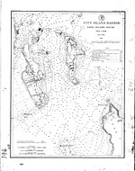
As an example of how variation changes over time, see the two charts of the same area (western end of Long Island Sound), below, surveyed 124 years apart.
Polaris currently traces a circle 0.73° in radius around the north celestial pole, so this technique is accurate to within a degree.
At high latitudes a plumb-bob is helpful to sight Polaris against a reference object close to the horizon, from which its bearing can be taken.
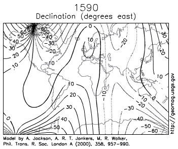
[5] A rough estimate of the local declination (within a few degrees) can be determined from a general isogonic chart of the world or a continent, such as those illustrated above.
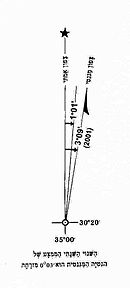
On the topographic maps of the U.S. Geological Survey (USGS), for example, a diagram shows the relationship between magnetic north in the area concerned (with an arrow marked "MN") and true north (a vertical line with a five-pointed star at its top), with a label near the angle between the MN arrow and the vertical line, stating the size of the declination and of that angle, in degrees, mils, or both.
However, the diagram itself is not an accurate depiction of the stated numerical declination angle, but is intentionally exaggerated by the cartographer for purposes of legibility.
It reflects a highly predictable rate of change,[a] and is usually more accurate than a map—which is likely months or years out of date.
A floating card compass always gives bearings in relation to magnetic north and cannot be adjusted for declination.
True north must be computed by adding or subtracting local magnetic declination.
Likewise, positive (easterly) deviation indicates that the compass needle is east of magnetic north.
Where: For example, if the compass reads 32°, the local magnetic variation is −5.5° (i.e. West) and the deviation is 0.5° (i.e. East), the true bearing will be:
Deviation varies for every compass in the same location and depends on such factors as the magnetic field of the vessel, wristwatches, etc.
More commonly, however, a correction card lists errors for the compass, which can then be compensated for arithmetically.
An exception is made for runways within the Northern Domestic Airspace of Canada; these are numbered relative to true north because proximity to the magnetic North Pole makes the magnetic declination large and changes in it happen at a high pace.
These bearings are then converted on a pre-flight plan by adding or subtracting the local variation displayed on a sectional chart.
This is accomplished by means of lookup tables inside the GPS which account for magnetic declination.
When onboard electronics fail, pilots can still rely on paper charts and the ancient and highly reliable device—the magnetic compass.