Mahanoy Creek
Mahanoy Creek is a 51.6-mile-long (83.0 km)[1] tributary of the Susquehanna River in Northumberland and Schuylkill counties, Pennsylvania.
Anthracite was mined in the upper part of the Mahanoy Creek watershed in the 19th and 20th centuries.
Schwaben Creek has a higher number and diversity of fish species than the main stem.
Mahanoy Creek's source is in strip mines in the eastern part of Schuylkill County, near Buck Mountain.
It begins paralleling Bear Ridge for several miles, passing the communities of St. Nicholas and Boston Run before entering Gilberton.
At Gordon, it picks up Little Mahanoy Creek and then turns west again, meandering out of Butler Township.
[4] Mahanoy Creek enters Northumberland County in East Cameron Township.
After a short distance, it leaves behind the Line Mountain/Mahanoy Mountain valley and picks up Zerbe Run.
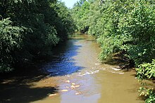
Mahanoy Creek then meanders west to its mouth on the Susquehanna River north of Herndon[8] and ten miles south of Sunbury.
The tributary Little Mahanoy Creek starts in Frackville and its watershed has an area of 11.6 square miles.
Additionally, there are trace amounts of various metals, including cobalt, nickel, copper, zinc, lead, sulfates, manganese, and beryllium.
The dissolved iron concentration in the abandoned mine drainage ranges from 0.01 to 33 milligrams per liter.
[10] The concentration of dissolved sulfates in the waters of Mahanoy Creek ranges from 4 to 597 milligrams per liter.
The dissolved nitrates concentration in the stream waters ranges from less than 0.01 to 6 milligrams per liter.
In the stream water, the concentration of dissolved phosphorus ranges from less than 0.01 to 0.3 milligrams per liter.
[10] The concentration of arsenic is above 0.2 micrograms per liter at most sites in the Mahanoy Creek watershed.
The discharge of acid mine drainage in the creek ranges from 0 to 17.2 cubic feet per second.
The lower part of the creek's watershed is in the Northern Shale Valleys and Slopes Ecoregion.
[11] The stream bed of Mahanoy Creek has an iron crust near Girardville, but some fish live in that area.
[10] Minerals in the acid mine drainage areas of the Mahanoy Creek watershed include goethite, ferrihydrite, schwertmannite, amorphous aluminum-hydroxysulfates, quartz, muscovite, kaolinite, and gypsum.
[10] Red shale of the Mauch Chunk Formation is found in a substantial part of the watershed.
[16] A number of seeps, boreholes, and mine tunnels contribute water to Mahanoy Creek throughout large sections of the watershed.
[12] Some buildings the Mahanoy Creek valley are damaged by subsidence due to underground mining.
[19] The eastern edge of the Mahanoy Creek watershed is marked by Locust Mountain and Vulcan Hill.
[14] Mahanoy Creek's name comes from a corruption of the Delaware Indian word mahoni[20] or maghonioy.
[22] Nathan Beach and several other people filed an application for 34 lots at the headwaters of Mahanoy Creek in 1794.
[9] A total of 12 million short tons of anthracite were mined in the creek's watershed in 1917.
[31] An October 2001 survey of Mahanoy Creek identified two species of fish each at Ashland and Girardville.
Additionally, 1003 individuals and 20 species of fish were observed at the mouth of the tributary Schwaben Creek.
[10] The Pennsylvania State Game Land Number 84 is located immediately south of Mahanoy Creek between Helfenstein and Dornsife.