Malabar Coast
[4][5] The peak of Anamudi, which is also the point of highest altitude in India outside the Himalayas, lies parallel to the Malabar Coast on the Western Ghats.
[1][10] The first element of the name is first attested in the Topography written by Cosmas Indicopleustes (6th century CE), which indicates that Arab sailors call Kerala Male already at that time.
[citation needed] Until the arrival of the British, the term Malabar was used in foreign trade circles as a general name for Kerala.
The southern part of this narrow coast is referred to as the South Western Ghats moist deciduous forests.
[citation needed] Malabar is also used by ecologists to refer to the Tropical and subtropical moist broadleaf forests of southwestern India (present-day Kerala).
[citation needed] Geographically, the Malabar Coast can be divided into three climatically distinct regions: the eastern highlands; rugged and cool mountainous terrain, the central mid-lands; rolling hills, and the western lowlands; coastal plains.
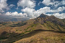
[19] The Western Ghats mountain range lie parallel to the coast on the eastern highland and separate the plains from the Deccan Plateau.
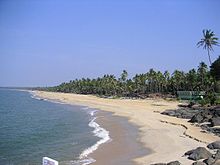
[20] Malabar's western coastal belt is relatively flat compared to the eastern region,[19]: 33 and is criss-crossed by a network of interconnected brackish canals, lakes, estuaries,[22] and rivers known as the Kerala Backwaters.
[4][24] The country's longest lake Vembanad, dominates the backwaters; it lies between Alappuzha and Kochi and is about 200 km2 (77 sq mi) in area.
Climate-wise, the Malabar Coast, especially on its westward-facing mountain slopes, comprises the wettest region of southern India, as the Western Ghats intercept the moisture-laden Southwest monsoon rains.
[27][28] A substantial portion of the Malabar Coast including the western coastal lowlands and the plains of the midland may have been under the sea in ancient times.
[29] Pre-historical archaeological findings include dolmens of the Neolithic era in the Marayur area of the Idukki district, which lie on the eastern highland made by Western Ghats.
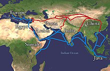
[32][19]: 79 Kerala's spices attracted ancient Arabs, Babylonians, Assyrians and Egyptians to the Malabar Coast in the 3rd and 2nd millennia BCE.
[33] The Arabs on the coasts of Yemen, Oman, and the Persian Gulf, must have made the first long voyage to Malabar and other eastern countries.
[33] The Greek historian Herodotus (5th century BCE) records that in his time the cinnamon spice industry was monopolized by the Egyptians and the Phoenicians.
[40] Contemporary Sangam literature describes Roman ships coming to Muziris in Kerala, laden with gold to exchange for Malabar pepper.
One of the earliest western traders to use the monsoon winds to reach Kerala was Eudoxus of Cyzicus, around 118 or 166 BCE, under the patronage of Ptolemy VIII, king of the Hellenistic Ptolemaic dynasty in Egypt.
[41][42] The term Kerala was first epigraphically recorded as Ketalaputo (Cheras) in a 3rd-century BCE rock inscription by emperor Ashoka of Magadha.
During the early Middle Ages, Namboodiri Brahmin immigrants arrived in Kerala and shaped the society on the lines of the caste system.
He travelled extensively across the Indian subcontinent founding institutions of the widely influential philosophy of Advaita Vedanta.
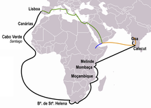
[45] The port at Kozhikode acted as the gateway to medieval South Indian coast for the Chinese, the Arabs, the Portuguese, the Dutch, and finally the British.
In pursuit of peace, the Zamorin agreed to indemnify Travancore for war expenses and vowed perpetual friendship, marking a triumph of strategy and valor led by Pillai.
[47][48] After the Dutch were defeated by Travancore king Marthanda Varma, the British crown gained control over Kerala through the creation of the Malabar District in northern Kerala and by allying with the newly created princely state of Travancore in the southern part of the state until India was declared independent in 1947.