Malaysia Airlines Flight 370
Relying mostly on the analysis of data from the Inmarsat satellite with which the aircraft last communicated, the Australian Transport Safety Bureau (ATSB) initially proposed that a hypoxia event was the most likely cause given the available evidence, although no consensus has been reached among investigators concerning this theory.
At various stages of the investigation, possible hijacking scenarios were considered, including crew involvement, and suspicion of the airplane's cargo manifest; many disappearance theories regarding the flight have also been reported by the media.
In the absence of a definitive cause of disappearance, air transport industry safety recommendations and regulations citing Flight 370 have been implemented to prevent a repetition of the circumstances associated with the loss.
On 24 March, the Malaysian government noted that the final location determined by the satellite communication was far from any possible landing sites, and concluded, "Flight MH370 ended in the southern Indian Ocean.
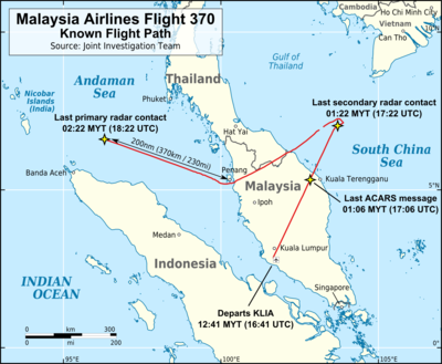
Based on analysis of the satellite communications, the aircraft was postulated to have turned south after passing north of Sumatra and then to have flown for six hours with little deviation in its track, ending when its fuel was exhausted.
[50][51] The airline also sent its own team of caregivers and volunteers[52] and agreed to bear the expense of bringing family members of the passengers to Kuala Lumpur and providing them with accommodation, medical care, and counselling.
[81] On 24 March, Malaysian Prime Minister Najib Razak appeared before media at 22:00 local time to give a statement regarding Flight 370, during which he announced that he had been briefed by the Air Accidents Investigation Branch that it and Inmarsat (the satellite data provider) had concluded that the airliner's last position before it disappeared was in the southern Indian Ocean.
[112] On 12 March, the chief of the Royal Malaysian Air Force announced that an unidentified aircraft—believed to be Flight 370—had travelled across the Malay peninsula and was last sighted on military radar 370 km (200 nmi; 230 mi) northwest of the island of Penang; search efforts were subsequently increased in the Andaman Sea and Bay of Bengal.
[120] The search area, which Australian prime minister Tony Abbott called "as close to nowhere as it's possible to be", is renowned for its strong winds, inhospitable climate, hostile seas, and deep ocean floors.
[124] Revised estimates of the radar track and the aircraft's remaining fuel led to a move of the search 1,100 km (590 nmi; 680 mi) northeast of the previous area on 28 March,[125][126][127] which was followed by another shift on 4 April.
[143] This phase of the search, which began on 6 October 2014,[139] used three vessels equipped with towed deep-water vehicles that use side-scan sonar, multi-beam echo sounders, and video cameras to locate and identify aircraft debris.
[145][146][147] Following the discovery of the flaperon on Réunion, the Australian Transport Safety Bureau (ATSB) reviewed its drift calculations for debris from the aircraft and, according to the JACC, was satisfied that the search area was still the most likely crash site.
[170] By October 2017, twenty pieces of debris believed to be from 9M-MRO had been recovered from beaches in the western Indian Ocean;[171] 18 of the items were "identified as being very likely or almost certain to originate from MH370", while the other two were "assessed as probably from the accident aircraft.
[181][182][183][184] After the discovery, French police conducted a search of the waters around Réunion for additional debris,[178][185][186] and found a damaged suitcase that was initially linked to Flight 370,[187] but officials have since doubted this connection.
[197] In late February 2016, an object bearing a stencilled label of "NO STEP" was found off the coast of Mozambique; early photographic analysis suggested that it could have come from the aircraft's horizontal stabiliser or from the leading edges of the wings.
[202][203] In December 2015, Liam Lotter had found a grey piece of debris on a beach in southern Mozambique, but only after reading in March 2016 about Gibson's find—some 300 km (190 mi) from his own—did his family alert authorities.
[217] Texas A&M University mathematics professor Goong Chen has argued that the plane may have entered the sea vertically; any other angle of entry would make the aircraft splinter into many pieces, which would have been found already.
[60] After last contact by primary radar west of Malaysia, the following events were recorded in the log of Inmarsat's ground station at Perth, Western Australia (all times are MYT/UTC+8):[60]: 18 [62][n] The aircraft did not respond to a ping at 09:15.
[citation needed] The log-on request sent earlier in the flight at 02:25 also reveals that the satellite communication system was offline from some point after the final ACARS transmission at 01:06 until 02:25, possibly due to a power interruption.
[249][250][251] In 2020, former Australian Prime Minister Tony Abbott stated in a Sky News documentary: "My very clear understanding, from the very top levels of the Malaysian government, is that from very, very early on, they thought it was murder-suicide by the pilot.
Malaysian Prime Minister, Najib Razak, said it was clear that the radar transponders and the flight data transmission system were turned off deliberately by someone trying to hide the plane's position and heading.
[295] Vietnam temporarily scaled back its search operations after the country's Deputy Transport Minister cited a lack of communication from Malaysian officials despite requests for more information.
[296] China, through the official Xinhua News Agency, urged the Malaysian government to take charge and conduct the operation with greater transparency, a point echoed by the Chinese Foreign Ministry days later.
Lack of evidence in determining the cause of Flight 370's disappearance, as well as the absence of any physical confirmation that the airplane crashed, raises many issues regarding responsibility for the accident and the payments made by insurance agencies.
[336][337] The Malaysian Prime Minister, Najib Razak, responded to criticism of his government in an opinion piece published in The Wall Street Journal in which he acknowledged mistakes had been made, and said time would show that Malaysia had done its best, had helped co-ordinate the search, and would continue to provide support.
[355] An op-ed in state media outlet China Daily said that Malaysia was not wholly to be blamed for its poor handling of such a "bizarre" and "unprecedented crisis," and appealed to the Chinese relatives not to allow emotions to prevail over evidence and rationality.
The IATA's task force planned to come up with several short-, medium-, and long-term solutions to ensure that information is provided in a timely manner to support search, rescue, and recovery activities in the wake of an aircraft accident.
[378] In March, the ICAO approved an amendment to the Chicago Convention requiring new aircraft manufactured after 1 January 2021 to have autonomous tracking devices which could send location information at least once per minute in distress circumstances.
[370] The intensive and urgent search for the flight recorders in early April 2014, due to the 30-day battery life of the underwater locator beacons (ULBs) (or "pingers") attached to them, drew attention to their inherent limitations.
[384] The European Aviation Safety Agency (EASA) issued new regulations that require the transmitting time of ULBs fitted to aircraft flight recorders to be increased from 30 to 90 days, to be implemented by 1 January 2020.