Malheur National Wildlife Refuge
The refuge was created in 1908 by order of President Theodore Roosevelt to protect habitat for diverse waterfowl and migratory birds, and grew to encompass 187,757 acres (760 km2; 293 sq mi) of public lands.
A popular site for birding, fishing, hunting and hiking, the refuge gained widespread attention in early 2016 after its headquarters complex was occupied by armed anti-government protesters.
Archaeological research within the Harney Basin region, including near Burns, Oregon, demonstrates that it likely was home to Native Americans for about the past 16,000 to 15,000 years.
Around Malheur and Harney lakes, the presence of identifiable remains of numerous settlements and burials of the Boulder Village Period demonstrate that these lakes were heavily utilized by Paiute tribes for hunting and fishing as part of their seasonal nomadic round of the Harney Valley from before 3,000 BP up until historic contact with and settlement of the area by non-Native peoples.
[2][3] For example, the Malheur National Wildlife Refuge Headquarters lies within a major archaeological site that was once a settlement used by Paiute tribes seasonally for thousands of years until historic contact.
[5] After it was established, the size of the Malheur Indian Reservation continued to shrink as small areas of it were repeatedly extracted from it and transferred to local settlers for their private use.
[9][10] Beginning in the late 1880s, the area's bird populations were devastated by the actions of plume hunters who harvested the showy feathers of Malheur's waterfowl for use as hat ornaments.
[11][12] In 1908, wildlife photographers William L. Finley and Herman Bohlman documented the area's unusual diversity of birds, as well as the detrimental impacts of plume hunting.
The creation and expansion of this refuge involved litigation, of which two lawsuits ended in favorable Supreme Court decisions, that provide the legal foundation for its ownership and management by federal agencies.
[15][18] Drafting of a new management plan began in 2008, and was a collaborative process involving varied stakeholders in the refuge's future, including ranch operators.
[22] Various stakeholders interested in the protection of the refuge, including the Portland Audubon Society and the Burns Paiute Tribe, voiced unease about potential impacts of an extended occupation.
Among their concerns were the delayed implementation of work to improve conditions for the annual spring migration of birds, halting of efforts to control invasive common carp, and protection of archaeological sites within the refuge.
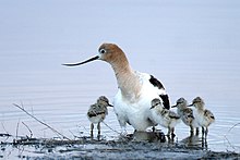
Malheur is one of the most productive waterfowl breeding areas in the United States and is an essential migration stop for hundreds of thousands of birds following the Pacific Flyway.
In addition, the expansive open water within Malheur Lake provides security for molting geese and ducks that exceeded 10,000 in number from predators.
Six of these redband trout populations exist as small communities in isolated creeks that dissipate onto the valley floor in the northeast and southeast regions of the basin.
Together with adjacent acreage owned by the Bureau of Land Management, Malheur National Wildlife Refuge in part provides critical protection to these redband trout populations.
Carp are aggressive feeders that have reduced food availability and diminished habitat quality for the bird species that utilize the refuge's marshes and lakes.
Within Malheur National Wildlife Refuge, paleontologists have found the fossil bones of an unidentified camel-like species in Pleistocene volcanic ash deposits.
[39] Finally, Late Pleistocene, 22,000 year-old, fossil salmon bones have been reported being found in prehistoric gravel spawning beds that were uncovered near the connection between Malheur and Mud lakes.