Manchuria
The exact geographical extent varies depending on the definition: in the narrow sense, the area constituted by three Chinese provinces of Heilongjiang, Jilin, and Liaoning but broadly also including the eastern Inner Mongolian prefectures of Hulunbuir, Hinggan, Tongliao, and Chifeng, collectively known as Northeast China; in a broader sense, the area of historical Manchuria includes the aforementioned regions plus the Amur river basin, parts of which were ceded to the Russian Empire by the Manchu-led Qing dynasty during the Amur Annexation of 1858–1860.
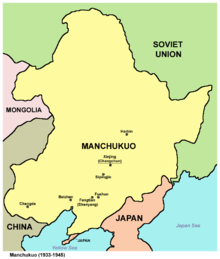
[3]: 3 [5] The former Japanese puppet state of Manchukuo further included the prefectures of Chengde (now in Hebei), and Hulunbuir, Hinggan, Tongliao, and Chifeng (now in Inner Mongolia).
[7] Various senses of Greater Manchuria sometimes further include Sakhalin Island, which despite its lack of mention in treaties was shown as Qing territory on period Chinese, Japanese, Russian, and French maps of the area.
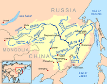
[citation needed] The drainage basin of the Amur River apart to the east towards Mongolia roughly corresponds to the geographical area of the historic land of the Manchu people.
"Manchuria" – variations of which arrived in European languages through Dutch – is a calque of Latin of the Japanese placename Manshū (満州, "Region of the Manchus"), which dates from the 18th century.
[11] According to Junko Miyawaki-Okada, Japanese geographer Takahashi Kageyasu was the first to use the term Manshū as a toponym in 1809 in the Nippon Henkai Ryakuzu, and it was from that work that Westerners adopted the name.
[2] Manshū then increasingly appeared on maps by Japanese cartographers such as Kondi Jūzō, Takahashi Kageyasu, Baba Sadayoshi, and Yamada Ren.
[1][2][18] The term Manchuria has been described as "controversial" or "troublesome" by several scholars including Mark C. Elliott, Norman Smith, and Mariko Asano Tamanoi.
The historian Norman Smith wrote that "The term 'Manchuria' is controversial" based on reasons outlined by Mariko Asano Tamanoi in the "Introduction" of Crossed Histories: Manchuria in the Age of Empire (2005).
Japanese colonists who returned to Japan from Manchukuo in the post-war period used terms such as Manshu (Manchuria), Man-mō (Manchuria-Mongolia), and Mō-man (Mongolia-Manchuria) almost interchangeably.
[16][2] Hyphenated terms such as Man-sēn (Manchuria and Korea) and Man-mō (Manchuria-Mongolia) emerged in Japanese media and traveler writings during the first three decades of the 20th century, implying that these regions were extensions of each other.
[21] Others such as Forêt described Manchuria as a solely geographical term without indicating a political connection and used it in that capacity despite acknowledging its imperialistic overtones.
This usage is seen in the expression Chuǎng Guāndōng (literally "Rushing into Guandong") referring to the mass migration of Han Chinese to Manchuria in the 19th and 20th centuries.
[36] Soils are mostly fertile mollisols and fluvents except in the more mountainous parts where they have poorly developed orthents, as well as in the extreme north where permafrost occurs and orthels dominate.
[37] The climate of Manchuria has extreme seasonal contrasts, ranging from humid, almost tropical heat in summer to windy, dry, Arctic cold in winter.
This pattern occurs because the position of Manchuria on the boundary between the great Eurasian continental landmass and the huge Pacific Ocean causes complete monsoonal wind reversal.
[39] In winter, however, the vast Siberian High causes very cold, north-to-northwesterly winds that bring temperatures as low as −5 °C (23 °F) in the extreme south and −30 °C (−22 °F) in the north[40] where the zone of discontinuous permafrost reaches northern Heilongjiang.
This explains why corresponding latitudes of North America were fully glaciated during glacial periods of the Quaternary while Manchuria, though even colder, always remained too dry to form glaciers[41] – a state of affairs enhanced by stronger westerly winds from the surface of the ice sheet in Europe.
[citation needed] Various ethnic groups and their respective kingdoms, including the Sushen, Donghu, Xianbei, Wuhuan, Mohe, Khitan and Jurchens, have risen to power in Manchuria.
[47] The Qing dynasty built the Willow Palisade – a system of ditches and embankments – during the later 17th century to restrict the movement of Han civilians into Jilin and Heilongjiang.
It was also common to use "China" (Zhongguo, Dulimbai gurun) to refer to the Qing in official documents, international treaties, and foreign affairs.
[52] The Qing resettled Han Chinese farmers from north China to the area along the Liao River in order to restore the land to cultivation.
[55] The Qianlong Emperor (r. 1735–1796) allowed Han Chinese peasants suffering from drought to move into Manchuria despite his having issued edicts in favor of banning them from 1740 to 1776.
In the late 18th century, Manchus in Beijing were sent to Manchuria as part of a plan to reduce the burden on the court, but they tried to return by every means possible.
[68] In 1858 Russian diplomacy forced a weakening Qing dynasty to cede Manchuria north of the Amur to Russia under the Treaty of Aigun.
Without occupying Manchuria, the Japanese probably could not have carried out their plan for conquest over Southeast Asia or taken the risk of attacking the United States and the British Empire in 1941.
After Zhang was defeated in the Northern Expedition and retreated back to Manchuria from Beijing, Japanese army officers assassinated him[51]: 41 on 2 June 1928, in what is known as the Huanggutun Incident.
Under Japanese control, Manchuria was brutally run, with a systematic campaign of terror and intimidation against the local populations including arrests, organised riots and other forms of subjugation.
The Kuomintang government in Taiwan (Formosa) complained to the United Nations, which passed resolution 505 on 1 February 1952, denouncing Soviet actions over the violations of the 1945 Sino-Soviet Treaty of Friendship and Alliance.
[51]: 1 Strongly influenced by the Soviet approach to industrialization, development policy focused on heavy-industry state-owned enterprises, such as Angang in Anshan.