Manhattanville, Manhattan
It was the first station on the Hudson River Railroad running north from the city, and the hub of daily stage coach, omnibus and streetcar lines.
Situated near Bloomingdale Road, its hotels, houses of entertainment and post office made it an alluring destination of suburban retreat from the city, yet its direct proximity to the Hudson River also made it an invaluable industrial entry point for construction materials and other freight bound for Upper Manhattan.
With the construction of road and railway viaducts over the valley in which the town sat, Manhattanville, increasingly absorbed into the growing city, became a marginalized industrial area.
The village's original streets were laid out by Jacob Schieffelin and other wealthy merchants, mostly Quakers, who had country seats in the area.
During the American Revolutionary War, the valley was also known as the Hollow Way, where the main action of the Battle of Harlem Heights began under the command of General George Washington.
During the War of 1812 the valley's southern ridges figured as the site of the Manhattanville Pass, whose defense fortifications and breastworks included Fort Laight and Blockhouse No.
Manhattanville's early population was a diverse and eclectic mix of intermarried American patriots and British loyalists; at least one prominent former African slave trader (this seems to be a reference to Michael Hogan, whose wife was of mixed British and Indian ancestry, born in Bombay); slave owners and enslaved African-Americans; Quaker anti-slavery activists and free black abolitionists; tradesmen, poor laborers and wealthy industrialists.
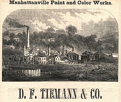
The Tiemann laboratory and factory which was originally located on 23rd Street and Fourth Avenue in Gramercy, near Madison Square Park, relocated uptown to Manhattanville in 1832, in part due to an underground spring of running water at the new uptown location, which is today the site of 560 Riverside Drive.
"[12] In the late nineteenth century, Manhattanville experienced a development boom of residential buildings, churches, hospitals, institutional construction, and transportation made it a desirable location for the brewery business.
After the American Civil War, the Jewish immigrant population that began to distinguish itself in Harlem gradually filtered into the western blocks of Manhattanville (and established Chevra Talmud Torah Anshei Marovi, also known as Old Broadway Synagogue, in 1911).
In 1904, the opening of the Interborough Rapid Transit Company (IRT)'s new Broadway–Seventh Avenue Line, now part of the 1 train on the New York City Subway, galvanized Manhattanville's radical transformation from rural exburb to an extension of the growing city, with the elevated railway providing rapid transit downtown.
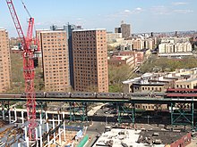
By the 1970s, the southern part of Manhattanville (up to about 125th Street) was being filled by Columbia and Barnard College students, staff and faculty, as the university continued to expand.
Many of the buildings below 125th Street have converted to cooperative ownership as the area experiences continuing gentrification and increasing demand for housing.
According to the plan, the physical plant of those blocks will be partly demolished to construct a new campus, secondary school and park land, designed by Italian architect Renzo Piano.
To the north, the 589-student dorm The Towers[18] finished construction in June 2006 as an extension of the City College of New York on St. Nicholas Terrace.
[citation needed] In 2006, Jewish Theological Seminary of America opened a smaller dormitory on 122nd Street between Broadway and Amsterdam Avenue.
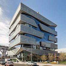
[citation needed] In August 2009, at 135th Street and Convent Avenue, City College completed the construction of a new 135,000-square-foot (12,500 m2) School of Architecture and Urban Design building (The Bernard and Anne Spitzer School of Architecture, named after the New York real estate developer and philanthropist, Bernard Spitzer and his wife).
[19][20] Based on a pre-existing 1950s structure, the old Cohen Library on South Campus, this redesign and reconstruction by Rafael Viñoly Architects is intended to add a modern aesthetic to the eclectic architectural mix in the area.
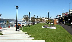
It opened in early October 2008, delayed through the summer by the discovery that fencing designed to prevent users from falling into the river did not meet specifications.
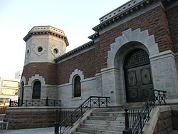
Artistic revitalization continued in October 2006 when The Gatehouse Theater opened as an additional facility of Aaron Davis Hall,[23] a venue specializing in dance.
Upon completion, both Aaron Davis Hall and the Gatehouse Theater evolved to share a common name, Harlem Stage.
Designed in the international "towers in the park" style by noted Swiss-born architect William Lescaze, the development was initially created to house middle income residents.
The neighborhood also contains the landmarked neo-Renaissance Claremont Theatre where Thomas Edison once shot a short film in 1915 featuring the building's entrance,[29][30][31] the Manhattanville Bus Depot, St. Mary's Church, and the Fairway Supermarket, whose broad selections attract distant customers.
[26]: 14 The concentration of fine particulate matter, the deadliest type of air pollutant, in Community District 9 is 0.008 milligrams per cubic metre (8.0×10⁻⁹ oz/cu ft), more than the city average.
[26]: 6 The percentage of Community District 9 students excelling in math rose from 25% in 2000 to 49% in 2011, and reading achievement increased from 32% to 35% during the same time period.
[27]: 24 (PDF p. 55) [26]: 6 Additionally, 65% of public high school students in Community District 9 graduate in four years, less than the citywide average of 75%.