Manisa
In fact, İzmir's proximity also adds a particular dimension to all aspects of life's pace in Manisa in the form of a dense traffic of daily commuters between the two cities, separated as they are by a half-hour drive served by a fine six-lane highway nevertheless requiring attention at all times due to its curves and the rapid ascent (sea-level to more than 500 meters at Sabuncubeli Pass) across Mount Sipylus's mythic scenery.
In the last couple of decades, Manisa's width more than tripled in size across its vast plain formed by the alluvial deposits of the River Gediz, a development in which the construction of new block apartments, industrial zones and of Celal Bayar University campus played a key role.
It is also a departure point for other visitor attractions of international acclaim which are located nearby within Manisa's depending region, such as Sardes and Alaşehir (ancient Philadelphia) inland.
Traditional view held that the name "Magnesia" is derived from the tribe of Magnetes who would have immigrated here from Thessaly at the dawn of the region's recorded history.
Some of these footprints are on display today in Manisa Museum while their site of origin of Sindel, where there are also prehistoric paintings, will reportedly become Turkey's first geopark through a joint project with the European Commission.
The second finds are tombs contemporaneous with Troy II (3000-2500 BC) and found in the village of Yortan near Kırkağaç district center, north of Manisa.
Original burial practices observed in these sepulchres led scholars to the definition of a "Yortan culture" in Anatolia's prehistory, many of whose aspects remain yet to be explored.
[7] Central and southern parts of western Anatolia entered history with the still obscure Luwian kingdom of Arzawa, probably offshoots, as well as neighbors and, after around 1320 BCE, vassals of the Hittite Empire.
Cybele monument located at Akpınar on the northern flank of Mount Sipylus, at a distance of 7 km (4 mi) from Manisa on the road to Turgutlu is, along with the King of Mira rock relief at Mount Nif near Kemalpaşa and a number of cuneiform tablet records are among the principal evidence of extension of Hittite control and influence in western Anatolia based on local principalities.
Such semi-legendary figures like the local ruler Tantalus, his son Pelops, his daughter Niobe, the departure of a sizable part of the region's population from their shores to found, according to one account, the future Etruscan civilization in present-day Italy, are all centered around Mount Sipylus, where the first urban settlement was probably located, and date from the period prior to the emergence of the Lydian Mermnad dynasty.
It has also been suggested that the mountain could be the geographical setting for Baucis and Philemon tale as well, while most sources still usually associate it with Tyana (Hittite Tuwanuwa) in modern-day Kemerhisar near Niğde.
Although the sanjak of Saruhan officially depended on the eyalet of Anadolu with its seat in Kütahya, a large degree of autonomy was left to the princes for them to acquire the experience of government.
This practice was discontinued in 1595, largely due to the growing insecurity in the countryside, precursor of Jelali Revolts, and a violent earthquake dealt a severe blow to the Manisa region's prosperity the same year.
Around 1700, Manisa counted about 2,000 taxpayers and 300 pious foundations (vakıf) shops, was renowned for its cotton markets and a type of leather named after the city.
Large parts of the population had begun settling and becoming sedentary and the city was a point of terminus for caravans from the east, with İzmir's growth still in its early stages.
[11] But already during the preceding century, influent western merchants such as Orlando, often in pact with local warlords such as Cennetoğlu, a brigand (sometimes cited as one of the first in line in western Anatolia's long tradition of efes to come) who in the 1620s had assembled a vast company of disbanded Ottoman soldiers and renegades and established control over much of the fertile land around Manisa, had triggered a movement of more commercially sensitive Greek and Jewish populations towards the port city.
[b] Instead of being laid along the direct route eastwards from Smyrna to Kasaba, about fifty kilometers in length, the line built drew a wide arc advancing first to the north-west from İzmir, through its Karşıyaka suburb to whose foundation it contributed greatly, and curves eastwards only from Menemen on, crossing the former sanjak and the present-day province center of Manisa to join Kasaba (now Turgutlu) from the north.
Price sold the whole network in 1893 to the Franco-Belgian group Compagnie Internationale des Wagons-Lits, which extended it further east to Afyonkarahisar in 1896 and further north to Bandırma in 1912.
[15][full citation needed] James Loder Park, the U.S. Vice-Consul in Constantinople at the time, who toured much of the devastated area immediately after the Greek evacuation, described the situation in the surrounding cities and towns of Smyrna he has seen, as follows:[16] "Magnesia...almost completely wiped out by fire...10,300 houses, 15 mosques, 2 baths, 2,278 shops, 19 hotels, 26 villas...[destroyed]."
Patrick Balfour, 3rd Baron Kinross wrote: "Out of the eighteen thousand buildings in the historic holy city of Manisa, only five hundred remained.
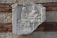
[23] The Muradiye Mosque of the 16th century was built by the great architect Mimar Sinan (and completed by Sedefkar Mehmed Agha), and the 'Murad Bey Medresse now houses the Archaeological Museum of Manisa.
The choice of Manisa as production base in the 1980s by the Turkish consumer electronics and white goods giant Vestel was an important boost for the present-day level of sophistication.