Mapleton, Utah
According to the United States Census Bureau, the city has a total area of 12.6 square miles (32.6 km2), all land.
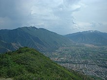
Between the two mountains is Maple Canyon, which is home to Whiting Campground in the Uinta-Wasatch-Cache National Forest.
Mapleton residents continue to call Spanish Fork Peak "Maple Mountain", despite the U.S. Board on Geographic Names having opted for the name that refers to the river and canyon that form its south base.
The city is bounded to the north by Hobble Creek and extends southward to the Ensign-Bickford plant in Spanish Fork.
The Mapleton Lateral Canal crosses the eastern side of the city, and the Bureau of Reclamation began piping it in 2007.
Mapleton is still a somewhat rural area but is rapidly suburbanizing in the wake of development.
Mapleton uses innovative planning techniques, including Transferable Development Rights (TDRs), to preserve the foothills.
Other landmarks include the "Old White Church" (The Church of Jesus Christ of Latter-Day Saints) at the southwest corner of Main and Maple streets, the Pioneer Heritage Museum and Levi Kendall Log Cabin located at 115 South Main Street, the Mapleton City Offices, located at 125 West Community Center Way (400 North), and the Mapleton City Public Works Building (1405 West 1600 North).