Marie-Galante
Marie-Galante[1] (French pronunciation: [maʁi ɡalɑ̃t], Antillean Creole: Mawigalant or Marigalant) is one of the dependencies of Guadeloupe,[2] an overseas department of France.
On 3 November 1493, he anchored at the islet now called Anse Ballet in Grand-Bourg, and named the island in honor of the flagship Marigalante (‘gallant Mary’) of the second voyage.
In 1660, at Basse-Terre Chateau, a peace treaty was signed in which the Caribs authorized the French and British to settle on the islands of Dominica and Saint Vincent.
In 1664, Madame de Boisseret gave up her rights to Marie-Galante to the Company of the West Indies, and the island then had its first four ox-powered mills.
[8] In August a small French force attempted to recapture the island but the British garrison, consisting of Royal Marines, augmented by Sir Alexander Cochrane's first Colonial Marines, newly recruited from escaped enslaved Africans of the island, and by some troops from the 1st West India Regiment, defeated and captured the French.
Many black people were killed during these uprisings which led to the dumping of rum and sugar from the Pirogue plantation into a nearby pond.
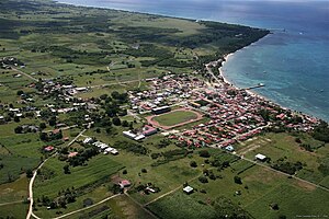
Marie-Galante comprises three communes of France: Grand-Bourg, Capesterre-de-Marie-Galante, and Saint-Louis, Guadeloupe, with a combined 1999 census population of 12,488 inhabitants.
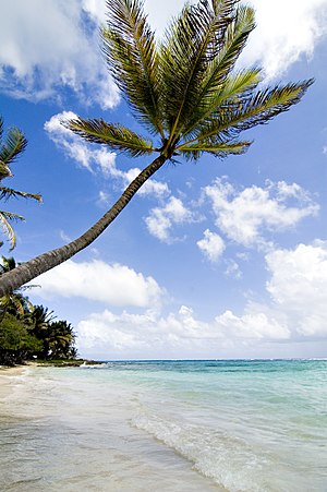
The island is more commonly known as la grande galette (‘the Big Biscuit’) due to its round shape and almost flat surface; its highest peak, the Morne Constant Hill, rises to 204 m. Formerly having over 106 sugar mills, it is also called "the Island of a Hundred Windmills" (French: lîle aux cent moulins).
In the East and the South, the plateau descends sharply to a coastal plain skirting the Atlantic Ocean from which it is protected by a barrier coral reef.
Marie-Galante is located in the northern hemisphere, it belongs to the Caribbean (or Antilles) archipelago, between the Tropic of Cancer and the Earth's equator.
The island of Marie-Galante is an elevated atoll[10] resting on a rugged limestone substrate, located on the outer arc of the Caribbean plate.
The north coast, facing Grande-Terre, is characterized by a high cliff, while the highest point, the Morne Constant (204 m altitude), is located to the east, in the territory of the municipality of Capesterre-de-Marie-Galante.
The agriculture (mainly exporting) of sugar cane, alcohol (rum) continues to be strongly encouraged, to make it more "sustainable" and to stop its recession by Europe, the French State and the local authorities (Region and Department).
Part of the terrestrial animal and plant heritage has been degraded as a result of human activities, except in the west, northwest, towards Saint-Louis, where the poorly developed fringing reefs still harbor many marine species.
[13] A 1,780 ha, 14 km long, stretch of Marie-Galante's northern coastline, encompassing the 120 m high cliffs, their inshore waters and the flat islet of Vieux Fort, has been recognised as an Important Bird Area (IBA) by BirdLife International because it supports seabird breeding colonies of red-billed tropicbirds, brown noddies and bridled terns.
[14] Maria Galante is subject to many natural hazards, such as earthquakes, tsunamis, volcanic eruptions, and tropical cyclones.
[15] On November 21, 2004, Marie-Galante, Guadeloupe and, in particular, the Saintes archipelago were hit by a violent earthquake measuring 6.3 on the Richter scale, which caused the death of one person and extensive material damage.
On November 29, 2007, an earthquake measuring between 6.8 and 7.3 on the Richter scale, with its epicenter southeast of Roseau, the capital of Dominica, shook the Antilles.
Since the passage of Hurricane Maria on September 18 in the Lesser Antilles, particularly in Dominica, where the eye of the cyclone passed, the archipelago of Guadeloupe, including "mainland Guadeloupe" and Marie-Galante saw the arrival of a mass exodus from Dominica, Dominiquais coming to take refuge on neighboring islands of their own, destroyed and almost unlivable.
In the 20th century, the large enslaved African plantations were forcibly abolished and gave place to small farms, organized into co-operatives.
But agriculture in the French West Indies is subject to global competition and by the beginning of the 21st century, one sugar refinery (usine de Grande-Anse) and three distilleries (Bellevue, Bielle, and Poisson) remained on Marie-Galante.
Remnants of the old economy still exist and Marie-Galante's rich history is a tourist attraction: a nature trail with 70 points of interest including two restored windmills (the Bézard Mill and the Bellevue Distillery), colonial dwellings and old sugar refineries (the Murat House and Mill) produces a network of paths for hikers to discover the island and its people.
The municipality of Saint-Louis has a subsidiary of the Pointe-à-Pitre Chamber of Commerce and Industry, and is developing an experimental photovoltaic plant project.
It consists of twenty-three two-bladed retractable wind turbines with a total installed power of 1,380 kW operated by the company Quadran 5.
A 7.5 MW biomass power plant will be built, fueled by bagasse (residue from sugar cane crushing) and household waste.
Since January 2020, a three-day jet ski stage race, created by Eric Paulin, organizer of the "Karujet", has been held on the Saint-Louis waterfront.
[19] In addition, the city of Capesterre, after 10 long years of work, inaugurated on July 30 its stadium called Stade José Bade,[20] with a capacity of at least 1,200 seats.
Every year, at the end of January, a big carnival parade is organized in the main city, Grand-Bourg since 2013, called WOY MI MASS.
The parade consists of about thirty decorated wagons pulled by a couple of oxen, along 22 km in the countryside and in Saint-Louis de Marie-Galante.
[21] The Mardi Gras is the big festival in which carnival groups compete in one of the towns of Marie-Galante depending on the year.