Maritime boundary
A maritime boundary is a conceptual division of Earth's water surface areas using physiographical or geopolitical criteria.
As such, it usually bounds areas of exclusive national rights over mineral and biological resources,[1] encompassing maritime features, limits and zones.
[2] The process of boundary delimitation in the ocean encompasses the natural prolongation of geological features and outlying territory.
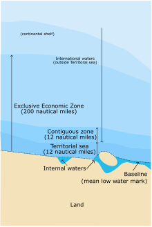
[9] The limits of maritime boundaries are expressed in polylines and in polygon layers of sovereignty and control,[10] calculated from the declaration of a baseline.
The conditions under which a state may establish such baseline are described in the United Nations Convention on the Law of the Sea (UNCLOS).
[1] In the case of overlapping zones, the boundary is presumed to conform to the equidistance principle or it is explicitly described in a multilateral treaty.
For example, in the 1982 Australia–France Marine Delimitation Agreement, for the purposes of drawing the treaty's equidistant lines it was assumed that France has sovereignty over Matthew and Hunter Islands, a territory that is also claimed by Vanuatu.
It consists of 21 straight-line maritime segments defined by 22 individual coordinate points forming a modified equidistant line between the two territories.
Among the array of unsettled disputes, the maritime borders of the two Koreas in the Yellow Sea represent a visually stark contrast.

A: Northern Limit Line , created by the United Nations in 1953 [ 19 ]
B: "Inter-Korean MDL in the Yellow Sea", declared by North Korea in 1999 [ 20 ] The locations of specific islands are reflected in the configuration of each maritime boundary, including: Other map features:
- Jung-gu (Incheon Intl. Airport)
- Seoul
- Incheon
- Haeju
- Kaesong
- Ganghwa County
- Bukdo Myeon
- Deokjeokdo
- Jawol Myeon
- Yeongheung Myeon