Marojejy National Park
"Unique in the world, a place of dense, jungly rainforests, sheer high cliffs, and plants and animals found nowhere else on earth",[3] Marojejy National Park has received plaudits in the New York Times[4] and Smithsonian Magazine[5] for its natural beauty and rich biodiversity that encompasses critically endangered members of the silky sifaka.
[9] The massif was not geologically described until after the French botanist Jean-Henri Humbert from the National Museum of Natural History in Paris explored the mountains in 1948.
[2] Originally seen as a transition zone between the eastern rainforests and the central highlands, Marojejy is now recognized as having its own unique features, with some of the richest biodiversity on the island.
[13] Due to illegal logging and trafficking of valuable hardwoods, and especially after the 2009 political crisis in Madagascar, the Rainforests of the Atsinanana was added to the list of World Heritage in Danger in 2010.
Many families from the local communities did not understand why such a large area so rich in resources and necessary for their survival was forbidden to them, and between the late 1980s and 1993, they stopped honoring the status of the park.
In 1993, the World Wide Fund for Nature (WWF) and the Service des Eaux et Forêts renewed conservation efforts in the area, evicted the people living inside the reserve, and renegotiated the borders with the local community, based on the 1966 decree.
[16] In 1998, the WWF requested that the government of Madagascar relax the restrictions on the reserve to allow for ecotourism, the revenue from which could benefit the people living in the periphery of the park.
The boundaries were renegotiated, particularly in the western and northwestern regions of the park, and this time using clear natural landmarks, such as ridge crests, as markers.
[1] Marojejy National Park covers 55,500 ha (214 sq mi) and protects almost the entire massif, which ranges in elevation from 75 to 2,132 m (246 to 6,995 ft) at the summit.
[20] As a result of this sharp rise in elevation and rugged topography, it has a variety of microclimates and a visible change in habitat,[21][22] making it one of the few places in the world where cloud-covered rainforest rapidly transitions to high mountain shrubland over a distance that can be covered on foot.
[17] The general region receives the most rainfall during the warm season, from November through April, when heavy rain and occasional cyclones are delivered from the northwest by monsoons.
[20] Marojejy is connected to the Anjanaharibe-Sud Special Reserve by the Betaolana corridor, a narrow mid-elevation strip of forest extending west and slightly south.
[25] As with the rest of Madagascar, the rocks of Marojejy National Park were once part of the supercontinent of Gondwana, which began to break up 160 million years ago to form the southern continents.
[26] However, the bedrock of Marojejy formed over 500 million years ago during the Precambrian beneath an ancient mountain range that has since eroded away completely.
In more recent geological times, the area's abundant quartzite formed when quartz-rich sands were deposited on the bedrock, and were then buried and recrystallized (metamorphosed).
The northern slopes dip moderately, while the southern faces are typically near-vertical cliffs where the rocks fractured counter to the layered grain.
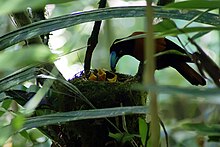
[35] Marojejy National Park is best known for its two iconic species, the helmet vanga (Euryceros prevostii)[17][36] and the critically endangered silky sifaka or simpona (Propithecus candidus).
[19] In addition to the silky sifaka, Marojejy is home to 10 other species of lemur,[29][30][37] several of which are also endangered due mainly to habitat loss.
[43] Marojejy National Park is open all year, with Bradt Travel Guides recommending April to May and September to December as the best times to visit due to less rainfall.
[46][48] The path into the rain forest is divided into three treks that vary in length and lead to each of the three main camps,[44] each of which is situated at different altitudes and offer views of their own distinctive flora and fauna.
[36][47] The first section of the path, known as the Mantella Trek, takes visitors just inside the park entrance, and leads to a picnic area after the first 2.5 km (1.6 mi).
[44][49] This camp is reported to be the best location for spotting the silky sifaka,[45] although the staff recommend that visitors hire a specialist tracker to aid in the search.
[44] The Marojejy Summit Trek continues up the mountain for another 2 km (1.2 mi) to Camp Simpona,[45] which is in the middle of the moist montane forest at an elevation of 1,250 m (4,100 ft).
[45][50] The rufous-headed ground-roller (Atelornis crossleyi) and yellow-bellied sunbird-asity (Neodrepanis hypoxantha) can be seen here, and a nearby stream teems with a diverse collection of frog species.
[50] Camp Simpona also serves as a basecamp for the steep climb to the summit of Marojejy Massif,[48] one of Madagascar's highest but most accessible peaks.
[45][50] The Andapa Basin, surrounded by the high, rugged mountains of Marojejy and Anjanaharibe-Sud, was extremely remote and difficult to access until relatively recently.
The crash of vanilla prices, along with a rapidly growing population and steady decrease in cultivatable land, has resulted in widespread and extreme poverty.
An increase in sustainable agriculture, silviculture, conservation awareness, and improved education and health care have also furthered the goal of protecting the environment and promoting livelihoods centered on the remaining forest.
Semi-precious gemstones, such as amethyst, are still mined within the boundaries of the park, while slash and burn agriculture and wood collection for firewood and construction continue to cause the periphery to recede.
[29] At the start of the Malagasy political crisis in March 2009, thousands of woodcutters intensely logged precious hardwoods for six to eight weeks in the SAVA Region.