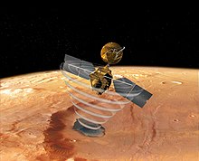
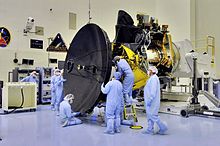
Mars Reconnaissance Orbiter
They are to provide data relay services from ground missions back to Earth, and characterize the safety and feasibility of potential future landing sites and Mars rover traverses.
[12] The Centaur upper stage of the rocket completed its burns over a 56-minute period and placed MRO into an interplanetary transfer orbit towards Mars.
[15] MRO began orbital insertion by approaching Mars on March 10, 2006, and passing above its southern hemisphere at an altitude of 370–400 kilometers (230–250 miles).
[19] On March 30, 2006, MRO began the process of aerobraking, a three-step procedure that halved the fuel needed to achieve a lower, more circular orbit with a shorter period.
[20][21][22] In September 2006, MRO fired its thrusters twice more to adjust its final, nearly circular orbit to approximately 250 to 316 km (155 to 196 mi) above the surface, with a period of about 112 minutes.
A stepping mechanism in the Mars Climate Sounder (MCS) skipped on multiple occasions resulting in a field of view that was slightly out of position.
[28] Also, an increase in noise and resulting bad pixels has been observed in several CCDs of the High Resolution Imaging Science Experiment (HiRISE).
Using the NASA rover Spirit as the point of origin for the transmission, the MRO acted as a relay for transmitting data back to Earth.
[32] The orbiter continued to experience recurring problems in 2009, including four spontaneous resets, culminating in a four-month shut-down of the spacecraft from August to December.
[36] On August 6, 2012 (sol 2483), the orbiter passed over Gale crater, the landing site of the Mars Science Laboratory mission, during its EDL phase.
The images revealed that Beagle 2 had actually landed safely, but one or two of its solar panels had failed to fully deploy, which blocked the radio antenna.
[38] On July 29, 2015, the MRO was placed into a new orbit to provide communications support during the anticipated arrival of the InSight Mars lander mission in September 2016.
In 2022, NASA announced the shutdown of CRISM in its entirety, and the instrument was formally retired on April 3, 2023, after creating two final, near global, maps using prior data and a more limited second spectrometer that did not require cryocoolers.
HiRISE's onboard computer reads these lines in time with the orbiter's ground speed, and images are potentially unlimited in length.
[24][57] To facilitate the mapping of potential landing sites, HiRISE can produce stereo pairs of images from which topography can be calculated to an accuracy of 0.25 m (9.8 in).
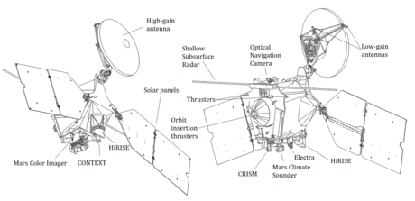
[58] HiRISE was built by Ball Aerospace & Technologies Corp.[59] The Context Camera (CTX) provides grayscale images (500 to 800 nm) with a pixel resolution up to about 6 m (20 ft).
CTX is designed to provide context maps for the targeted observations of HiRISE and CRISM, and is also used to mosaic large areas of Mars, monitor a number of locations for changes over time, and to acquire stereo (3D) coverage of key regions and potential future landing sites.
[60][61] The optics of CTX consist of a 350 mm (14 in) focal length Maksutov Cassegrain telescope with a 5,064 pixel wide line array CCD.
[73][74] Since beginning operation, it has helped create maps of mesospheric clouds,[75] study and categorize dust storms,[76] and provide direct evidence of carbon dioxide snow on Mars.
[79] The Shallow Radar (SHARAD) sounder experiment onboard MRO is designed to probe the internal structure of the Martian polar ice caps.
SHARAD emits HF radio waves between 15 and 25 MHz, a range that allows it to resolve layers as thin as 7 m (23 ft) to a maximum depth of 3 km (1.864 mi).
[87] The Optical Navigation Camera images the Martian moons, Phobos and Deimos, against background stars to precisely determine MRO's orbit.
Data from this investigation can be used to understand the subsurface geology of Mars, determine the density of the atmosphere and track seasonal changes in the location of carbon dioxide deposited on the surface.
The measurements helped provide greater understanding of seasonal wind variations, the effects of dust storms, and the structure of the atmosphere.
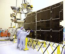
[95][83] Its high-efficiency solar cells are able to convert more than 26% of the energy it receives from the Sun directly into electricity and are connected together to produce a total output of 32 volts.
[99] Along with the Electra communications package, the system consists of a very large (3 m (9.8 ft)) antenna, which is used to transmit data through the Deep Space Network via X-band frequencies at 8.41 GHz.
NASA Deep Space Network (DSN) implemented Ka-band receiving capabilities at all three of its complexes (Goldstone, Canberra and Madrid) over its 34-m beam-waveguide (BWG) antenna subnet.
[100] Ka-band tests were also planned during the science phase, but during aerobraking a switch failed, limiting the X-band high gain antenna to a single amplifier.
These systems are all critically important to MRO, as it must be able to point its camera to a very high precision in order to take the high-quality pictures that the mission requires.
[117][118] Radar results from SHARAD suggested that features termed lobate debris aprons (LDAs) contain large amounts of water ice.