Charles Street (Baltimore)
Though not exactly at the west–east midpoint of the city, Charles Street is the dividing line between the west and east sides of Baltimore.
The terminus is immediately to the north of CSX's Locust Point Branch of the Baltimore Terminal Subdivision railroad line and I-95 and two blocks to the west of the historic National Enameling and Stamping Company factory complex.
The eastern leg of the park contains the George Peabody Sculpture and one of Severn Teackle Wallis facing St. Paul Street to the east.
The bifurcated Charles Street continues past the Roger B. Taney Sculpture in the northern square of the park, Mount Vernon Place United Methodist Church and Asbury House to the east, and The Stafford Apartments to the west and the equestrian statue of Col. John Eager Howard facing north towards Madison Street.
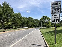
Charles Street continues one more block as an unnumbered highway before reaching the southern terminus of MD 139 at North Avenue, which carries US 1 and US 40 Truck.
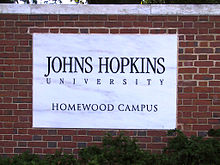
The boulevard passes between the main part of Charles Village and auxiliary Johns Hopkins University buildings to the east and the Baltimore Museum of Art and the Homewood Campus of Johns Hopkins University, and the campus's Homewood Museum to the west.
North of 33rd Street, Charles and St. Paul streets enter the Homewood neighborhood, where they each have oblique intersections with University Parkway, which leads northwest to the First Church of Christ, Scientist and the Lacrosse Museum and National Hall of Fame at the northern end of the Hopkins campus.
Two blocks north of the junction, four-lane undivided Charles Street intersects Cold Spring Lane.
Charles Street continues north between Homeland and Wyndhurst, the latter the home of the Friends School of Baltimore and the Cathedral of Mary Our Queen.
At Bellona Avenue, which heads northwest as MD 134, Charles Street becomes a four-lane divided highway that passes through an S-curve within a forested area.
The highway passes to the west of Greater Baltimore Medical Center and The Sheppard and Enoch Pratt Hospital, then intersects Towsontown Boulevard, which leads to the old alignment of Charles Street, Charles Street Avenue, and both Towson University and the center of Towson.
Charles Street veers northwest past the Loyola Blakefield school and north again to the top of a ridge where the highway passes under Joppa Road.
[9][10] The southern end was at the present day Lombard Street at what was called Uhler's Spring Branch.
[19] Construction was completed from the Beltway interchange south to Joppa Road and from MD 134 to Towsontown Boulevard in 1957.
[19][21][22] The bypass was marked as MD 139 by 1959 and the old segment of Charles Street Avenue was transferred to county maintenance by 1961.
[25] The intersection with Bellona Avenue at the state highway's northern terminus in Lutherville was replaced with a roundabout in 1999.
[26][27] This roundabout was later removed and replaced with a standard intersection as part of reconstruction of MD 139 and I-695 around their interchange that started in 2008.