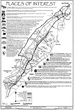
Baltimore–Washington Parkway
The road begins at an interchange with U.S. Route 50 (US 50) near Cheverly in Prince George's County at the Washington, D.C., border, and continues northeast as a parkway maintained by the National Park Service (NPS) to MD 175 near Fort Meade, serving many federal institutions.
Major reasons surrounding the need for a parkway included high accident rates on adjacent US 1 and defense purposes before World War II.
In the 1960s and the 1970s, there were plans to give the segment of the parkway owned by the NPS to the state and make it a part of I-295 and possibly I-95; however, they never came through and the entire road is today designated as MD 295, despite only being signed on the state-maintained portion.
US 50 west of the interchange heads into Washington, D.C., to become New York Avenue, and to its east becomes the John Hanson Highway, a freeway.
From its southern terminus, the road continues north as a six-lane freeway with the unsigned MD 295 designation, containing brown signs featuring the Clarendon typeface.
[6] It continues north as a four-lane freeway with a wide, tree-filled median, and passes through woodland, skirting residential neighborhoods hidden by the trees.
[4] This interchange is the only place where the park service has used green signs compliant with the Manual on Uniform Traffic Control Devices (MUTCD).
To the west of the parkway off MD 32 is the Savage Mill, which was an operating cotton mill from 1822 to 1947 and is currently an antique mall, and the Bollman Truss Railroad Bridge, an 1869 cast and wrought iron bridge along the Baltimore and Ohio Railroad, which is now CSX's Capital Subdivision, line between Baltimore and Washington D.C.[6] After this interchange, the road continues to a cloverleaf interchange with MD 175 (Jessup Road), where NPS maintenance of the parkway comes to an end at the south end of the interchange.
[6] Still on a northeast track, the route widens to six lanes and intersects West Nursery Road near Linthicum, adjacent to the BWI Hotel District.
Turning north, the route passes under MD 168 (Nursery Road) before crossing the Patapsco River into Baltimore County.
Now running due north, the parkway heads over CSX's Hanover Subdivision railroad line before it reaches its northern terminus at I-95.
[12] Federal and state officials commissioned the J. E. Greiner Company to create designs for the parkway, which included a large Y-junction at the southern terminus to connect with New York Avenue and the proposed Anacostia Freeway.
In addition, the road became a prime commuting route into both Washington and Baltimore, leading to suburban growth that would eventually cause the two distinct cities to merge into one large metropolitan area.
[17] In 1963, the State Roads Commission, the National Park Service, and the Bureau of Public Roads (the predecessor of the Federal Highway Administration) (FHWA) created tentative plans to transfer the NPS segment of the parkway to the state of Maryland, who would then rebuild it to modern freeway standards, with trucks and buses permitted throughout.
The designation was granted in 1969, but later withdrawn from all except the current portion signed as I-295 due to lack of funds available to modernize the route.
[21] As a result of the withdrawal of the Interstate designation, the parkway remained an unnumbered road south of I-695 while the portion north of there became a part of MD 3 by 1975.
[27] In the mid-1980s, the National Park Service, along with the Federal Highway Administration, began a reconstruction of the NPS segment to modernize the road, including the improvement of several interchanges.
[28][29] In 2004, Maryland Governor Robert L. Ehrlich announced plans to widen portions of MD 295 near Baltimore–Washington International Airport.
[32] The Maryland State Highway Administration closed the southbound ramps of the interchange between the Baltimore–Washington Parkway and Arundel Mills Boulevard starting Monday, May 7, 2012.
She suffered a heart attack that ended her congressional career on October 31, 1980, leaving her in a coma until her death on June 19, 1988.
[12][38][39][40] In 1989, an overpass being built at MD 198 over the B–W Parkway just east of Laurel collapsed during rush hour, injuring fourteen motorists and construction workers.
[41] On July 9, 2005, a sinkhole opened beneath the parkway at a construction site, leading to the complete closure of the northbound roadway.
The sinkhole was filled with concrete to shore up the roadbed and prevent further collapse; the U.S. Army Corps of Engineers attempted to expedite repairs, but the route remained closed until the next day.
[42] On August 24, 2007, both directions of the parkway were closed when chunks of concrete fell from the overpass at MD 193 (Greenbelt Road) onto the northbound lanes.
As part of the proposal, the portion of the parkway owned by the National Park Service would be transferred to the Maryland Transportation Authority.
[45] In 2019, portions of the National Park Service segment of the Baltimore–Washington Parkway experienced significant pavement deterioration, including several potholes.