List of state highways in Maryland shorter than one mile (900–999)
The following is a list of state highways in Maryland shorter than one mile (1.6 km) in length with route numbers between 900 and 999.
[1] Maryland Route 927 is the unsigned designation for the portion of Montrose Road at the interchange with I-270 in North Bethesda and Potomac in central Montgomery County.
[1] Maryland Route 928 is the unsigned designation for an unnamed road running from Clara Downey Avenue south to MD 28 in Norbeck, Montgomery County, serving a park and ride lot.
The 1953 bridge connects Greene Street in Cumberland with the northern terminus of West Virginia Route 28 Alternate in Ridgeley.
Maryland Route 949 is the unsigned designation for a segment of MD 49 that remains from that state highway being truncated following the construction of I-68 through La Vale in the 1970s.
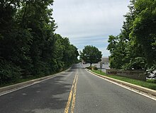
Maryland Route 952 is the unsigned designation for Hillcrest Drive, a 0.31-mile (0.50 km) C-shaped highway that connects a pair of right-in/right-out interchanges with each other on opposite sides of Exit 45 of I-68 in Cumberland.
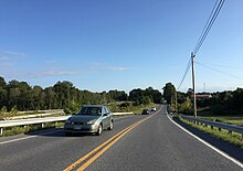
Known as Patriot Parkway, the two-lane highway begins at US 220, crosses CSX's Mountain Subdivision, and reaches its eastern terminus at the West Virginia state line at the North Branch Potomac River, where the highway continues as West Virginia Route 956 (WV 956) through Rocket Center.
The old road, whose northernmost part is now MD 53, crossed the North Branch Potomac River at Pinto.
[61] Maryland Route 958P is the unsigned designation for Crestmount Road, running from US 1 north to a cul-de-sac in Waterloo, Howard County.
It is located in Chillum in Prince George's County, is approximately 0.10 miles (0.16 km) long, and is aligned in a north–south direction.
It is located in Prince George's County, is approximately 0.24 miles (0.39 km) long, and is aligned in a north–south direction.
It is located in Prince George's County, is approximately 0.09 miles (0.14 km) long, and is aligned in a north–south direction.
[1] There are other separate segments of MD 967: Maryland Route 968 is the unsigned designation for the Entrance to the National Guard Armory.
It intersects Maryland Route 193 and ends approximately 200 feet (61 m) north of Convalescent Road in Greenbelt, Prince George's County.
[1] Maryland Route 969 is the unsigned designation for Eleanor Drive, which runs from MD 168 north to a dead end in Linthicum, Anne Arundel County.
It intersects Maryland Route 193 and ends approximately 200 feet (61 m) south of the Belvidere Avenue spur in Prince George's County.
[1] There are several separate segments of MD 976: Maryland Route 977 is the unsigned designation for several stretches of road in Prince George's County: Maryland Route 978 is the unsigned designation for several stretches of road in Prince George's County: Maryland Route 979 is the unsigned designation for Main Street, which connects U.S. 1 and city-maintained Main Street in Laurel, Prince George's County.
[1] Maryland Route 981 is the unsigned designation for Tricross Drive, a loop off of MD 108 in Columbia, Howard County.
[1] Maryland Route 984 is the unsigned designation for an unnamed service road which runs along the south side of US 40 near Normandy Drive east to Wheaton Way in Ellicott City, Howard County.
[1] Maryland Route 985 is the unsigned designation for Old Frederick Road, running from a dead end east to Rogers Avenue in Ellicott City, Howard County.
[1] Maryland Route 986 (officially MD 986M) is the unsigned designation for an unnamed road running from Prince Manor Way east to a dead end in Fulton, Howard County.
[1] Maryland Route 990 is the unsigned designation for an unnamed stub running from MD 177 south to a dead end in Pasadena, Anne Arundel County.
[1] Maryland Route 997 is the unsigned designation for three stretches of road in Anne Arundel County: Maryland Route 998A is the unsigned designation for MD 198 Service Road, running from the beginning of state maintenance east to Star Point Lane in Burtonsville, Montgomery County.