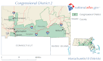
Massachusetts's 2nd congressional district
Massachusetts's 2nd congressional district is located in central Massachusetts, encompassing much of Franklin, Hampshire, and Worcester counties, as well as small portions of Middlesex and Norfolk Counties.
The largest municipalities in the district include Worcester (which is the second-largest city in New England after Boston), Leominster, Amherst, Shrewsbury, and Northampton.
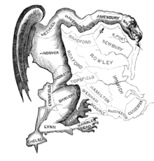
[4] From 1813-1815,[5] the district was shaped in such a way that poet and Federalist Richard Alsop described it as a "Gerry-mander" (a portmanteau of Gerry—the governor at the time—and salamander).
Illustrator Elkanah Tisdale subsequently used the term as the basis for a political cartoon, which popularized it and led to "gerrymandering" being used to describe the practice of manipulating electoral district boundaries to gain a political advantage.
[6] The Act of September 16, 1842, established the district on the North Shore and New Hampshire border, with the following municipalities:[7] "Parts of the counties of Bristol, Norfolk, and Plymouth.