Maui
[9] Popular tourist destinations include the resorts in the Kāʻanapali, Kapalua, and Kihei/Wailea/Makena areas; Hāna and the Hana Highway; Iao Valley; Haleakalā National Park; and its many beaches.
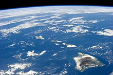
[10] Maui Island is also called the "Valley Isle" for the large isthmus connecting its northwestern and southeastern volcanic masses.
[11] The islands' volcanic cones are formed from basalt, a dark, iron-rich/silica-poor rock, which poured out of thousands of vents as fluid lava over millions of years.
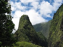
[12][better source needed] The older, western volcano has eroded considerably, forming the peaks of the West Maui Mountains (in Hawaiian, Mauna Kahalawai).
The larger, younger volcano to the east, Haleakalā, rises to 10,023 ft (3,055 m) above sea level, and measures 5 mi (8 km) from seafloor to summit.
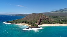
[citation needed] The eastern flanks of both volcanoes are cut by deeply incised valleys and steep-sided ravines that run downslope to the rocky, windswept shoreline.
During periods of reduced sea level, including as recently as 200,000 years ago,[15] the channels between them become exposed and join the island into a single landmass.
Annual rainfall averages 17–20 inches (430–510 mm) in leeward coastal areas, such as the shoreline from Maalaea Bay to Kaupo.
Big Bog, a spot on the edge of Haleakalā National Park overlooking Hana at about 5,400 ft (1,600 m) elevation had an estimated mean annual rainfall of 404 in (10,300 mm) over the 30-year period of 1978 to 2007.
[citation needed] Instead, the mountainous topography induces an average of about 70 in (1,800 mm).In the lowlands, rainfall is most likely to occur during night or morning hours, and least likely in mid-afternoon.
However, many have been damaged by pollution, run-off, and tourism, although sea turtles, dolphins, and Hawaii's celebrated tropical fish remain abundant.
The parrotbill lacks resistance to mosquito-born diseases, particularly avian malaria, so only forests above 1500 meters of elevation provide refuge.
[27] Birds found on other islands as well as Maui include the ʻIʻiwi (Drepanis coccinea], ʻApapane (Himatione sanguinea), Hawaiʻi ʻAmakihi (Chlorodrepanis virens), as Maui ʻAlauahio (Paroreomyza montana) well as the Nene (Branta sandvicensis, Hawaii's state bird), Hawaiian coot (Fulica alai), Hawaiian stilt (Himantopus mexicanus knudseni).
They introduced the kapu system, a strict social order that affected all aspects of life and became the core of Hawaiian culture.
Ships tended to stay for weeks rather than days, fostering extended drinking and the rise of prostitution, against which the missionaries battled.
In 1937, Vibora Luviminda trade union conducted the final ethnic strike action in the Hawaiian Islands against four Maui sugarcane plantations, demanding higher wages and the dismissal of five foremen.
Eventually, Vibora Luviminda made its point and the workers won a 15% increase in wages after 85 days on strike, but no written contract was signed.
Maui was involved in the Pacific Theater of World War II as a staging center, training base, and rest and relaxation site.
The proliferation of the wildfires was attributed to dry, gusty conditions created by a strong high-pressure area north of Hawaii and Hurricane Dora to the south.
[33] In 2016, Maui residents convinced officials to switch to organic pesticides for highway applications after they learned that label requirements for glyphosate formulations had not been followed.
[34] The new millennium brought droughts, increasing pressure on the ʻĪao aquifer, with withdrawals rising above 18 million U.S. gallons (68,000 m3) per day.
Recent estimates indicate that Maui has a potential supply of potable water around 476 million U.S. gallons (1,800,000 m3) per day, [citation needed] virtually all of which drains into the ocean.
Water for agriculture comes mostly from East Maui streams, routed through a network of tunnels and ditches dug by Chinese laborers in the 19th century.
[36] In 2009, the Office of Hawaiian Affairs and others successfully argued in court that sugar companies should reduce the amount of water they take from four streams.
[citation needed] Maui's primary agriculture products are corn and other seeds, fruits, cattle, wine, and vegetables.
The high elevation, dry climate, and freedom from light pollution offer virtually year-round observation of satellites, missiles, man-made orbital debris, and astronomical objects.
Maui's trade winds tend to come from the northeast, making the most popular places to snorkel on the sheltered south and west shores.
Kanaha Beach Park is a very well-known windsurfing spot and may have stand-up paddle boarders or surfers if there are waves and no wind.
Hāna Highway runs along the east coast, crossing many streams and passing black sand beaches and waterfalls.
While winning travel industry awards as Best Island In The World[59] in recent years some locals and environmentalists criticized what the saw as overdevelopment.