Mayapan
Mayapan (Màyapáan in Modern Maya; in Spanish Mayapán) is a Pre-Columbian Maya site a couple of kilometers south of the town of Telchaquillo in Municipality of Tecoh, approximately 40 km south-east of Mérida and 100 km west of Chichen Itza; in the state of Yucatán, Mexico.
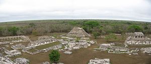
The ceremonial center has a tightly packed cluster of temples, colonnaded halls, oratories, shrines, sanctuaries, altars, and platforms (for oration, dancing, or stela display).
According to Dr. Gregory Simons survey outside the city walls, there were numerous additional dwellings and he revised the total population estimate to between 15,000–17,000 people.
Russell also found a colonnaded hall outside the city wall, revealing much is still to be discovered regarding the complexity of this urban landscape.
For example, most or all of the vaulted roofs in Mayapan have collapsed, while many of the better-built buildings at Chichen Itza remain intact.
Other major temples in the ceremonial center include three round ones, which are unusual for the Maya area and are also linked to the deity Kukulkan/Quetzalcoatl in his wind god (Ehecatl) aspect.
The extensive residential zones of the site are composed of dwellings and ancillary domestic structures, with those around the ceremonial district larger and of higher quality and those toward the fringes being generally poorer.
After a short civil war, the lords of various powerful cities and families met to restore a central government to Yucatán.
They decided to build a new capital city near the town of Telchaquillo, hometown of Hunac Ceel, the general who defeated the rulers of Chichen Itza.
(An alternative account is given in a Maya chronicle from the Colonial era, claiming that Mayapan was contemporary with Chichen Itza and Uxmal and allied with those cities, but archeological evidence shows this version to be less likely.)
Mayapan became the primary city in a group of allies that included much of the northern Yucatán, and trade partners that extended directly to Honduras, Belize, and the Caribbean island of Cozumel, and indirectly to Mexico.
Though Mayapan was ruled by a council, the Jalach winik and the aj k’in (the highest ruler, and the high priest) dominated the political sphere.
The social climate of Mayapan was made complicated by the antagonistic relationship between the factions of nobles, which were often arranged by kinship (Pugh 2009; Milbrath 2003).
As a result, all of the Cocom family, except one who was away in Honduras conducting trade, were killed, Mayapan was sacked, burned, and abandoned, all the larger cities went into decline, and Yucatán devolved into warring city-states.
The final report was published by the Carnegie Institution as Mayapan, Yucatan, Mexico, by H. E. D. Pollock, Ralph L. Roys, A. L. Smith, and Tatiana Proskouriakoff (1962, Publication 619).
Robert Smith published a two-volume monograph on The Pottery of Mayapan in 1971 (Papers of the Peabody Museum of Archaeology and Ethnology 66, Harvard University).
In the early 1990s, Clifford T. Brown of Tulane University carried out excavations in the residential zones of Mayapan as part of his doctoral dissertation research.
Several years later, the National Institute of Anthropology and History (INAH) of Mexico began extensive architectural excavations and consolidation under the direction of archaeologist Carlos Peraza Lope.
This "Economic Foundations of Mayapan" (PEMY) Project performed mapping, surface survey and collection, test-pitting, and horizontal excavation across the city.
Major findings of this project include the identification of diverse occupational specialization among the city's commoners, who worked as craftsmen, conscripted military personnel, farmers, and domestic servants.
Cenotes and underground limestone canals serve as the only source of freshwater in this area, making them essential to support agriculture.
Researchers have suggested that Mayapan was an import/export center, and that they often traded luxury goods, such as cotton, salt, and honey, for products of obsidian and metal, which they would have forged.
Also, citrus fruit such as oranges and limes are often grown within the domestic house groups of the local residents (Russell 2008:16).
Mayapan was a major capital in the Yucatán, and there is extensive evidence that it had far-reaching trade routes, as seen in architecture and artifacts of other settlements in the region.
A wide variety of goods were traded, including maize, honey, salt, fish, game, cloth, and birds.
The integration of classes extends to the outer edges of the residential areas probably due to the convenience of being close to the agricultural fields.
Some sources indicate that the analysis of oratorios or god-houses (large house-like shrines) show boundaries that were known to the people of Mayapan.
The strongest evidence for inequality in Mayapan is found in the presence of deep shafts full of sacrificial victims, this suggests that the noble class had enough power to condemn some people to death.