McKittrick Oil Field
The climate is hot and arid to semi-arid, with an average annual rainfall of 5 to 6 inches (130 to 150 mm), and summertime highs commonly exceeding 100 °F (38 °C).
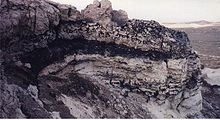
The predominant geologic feature, and the one that makes the McKittrick field distinctive, is the presence of a huge block of Monterey shale – more than 6 mi (9.7 km) long, approximately 1 mi (1.6 km) wide, and up to 2,000 ft (610 m) thick – which slipped off of the slopes of the adjacent Temblor Range during the Pleistocene and moved eastward onto the plain, almost entirely covering the field, and forming an impermeable cap over the oil-bearing rock.
This mass of stone, consisting of over 3 cu mi (13 km3) of rock, moved 2 to 3 miles (3.2 to 4.8 km) from its source region, and down about 2,000 feet (610 m) in elevation.
[4][5] Another unusual feature of the McKittrick field is its large tar seeps, points on the surface where petroleum has migrated upwards, forming pools.
The tar seeps outcrop in an area about 4 mi (6.4 km) long, adjacent to the McKittrick Thrust Fault, which defines the southwestern boundary of the oil field.
They are found in areas where the overlying Monterey formation, which tumbled down the Temblors during the Pleistocene, eroded away, exposing the oil-bearing strata.
Skeletons of many now-extinct mammals have been recovered, including camels, mammoths, dire wolves, saber toothed cats, deer, and bison.
In the Northeast Area, the Phacoides, Oceanic, and Point of Rocks pools vary from 7,900 to 9,100 ft (2,400 to 2,800 m) below ground surface; the temperature of the oil varies from 230 to 260 °F (110 to 127 °C) at that depth, and the initial reservoir pressures were also high, up to 4,100 psi (28,000 kPa), pressures that would have caused major blowouts and gushers during the early part of the century, but can be better managed with modern technology.