Menteng
Menteng is surrounded by the districts of Senen and Matraman to the east, Tebet and Setiabudi to the south, Tanah Abang to the west, and Gambir to the north.
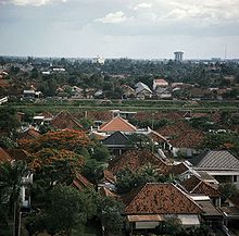
Menteng started as a neighbourhood project, characterised by a new urban design developed mainly in the 1910s as a residential area for Dutch Indonesians, the upper middle class, and high officials.
Thamrin Road is a major transportation artery in the district, with numerous offices, embassies, shopping centres, and residential apartments.
[5] Moojen was also a member of a development group established by Batavia city government, the Commisie van toesicht op het Geheer van het Land Menteng, which was responsible for planning and developing the larger area of Gondangdia (Nieuw Gondangdia) of which Menteng was the centerpiece.
[6] Karsten, in his 1939 memorandum to the colonial government, referring to Menteng Project and several other residential projects in the Indies - pointed out that real estate offices and the building trade have turned their attention to the needs of the upper middle class - particularly those of the Europeans, but moreover those of the small category categories of the other population groups in that class (i.e. natives and foreign orientals, mostly Chinese).
[6] Moojen's original plan for Menteng resembles the garden city model of Ebenezer Howard.
The plan combined wide cross-cutting boulevards with concentric rings of streets and a central public square.
Key difference with the original garden city model was that Menteng was not intended to be a freestanding, self-contained place, but to link up with adjacent residential areas.
For example, the broad Nassau Boulevard (now Jalan Imam Bonjol) that bisected the Menteng residential area adjacent to the central square (now Taman Suropati) was intended to connect Tanah Abang (an important market place) to the west and Meester Cornelis to the east.
The Java Street (Javaweg, now Jalan HOS Cokroaminoto) was to serve as a north–south connector from Kebon Sirih to the southern fringe of Batavia, the boundary was marked at that time by the line of a flood canal.
In the Kubatz plan, the street pattern was changed and a small pond (Situ Lembang) was added to the east of the central park area, originally named Bisschooplein after G.J.
During the period, houses in Menteng were built in two levels, partly to expand the building area without having to increase land plot.
The Menteng Project provided commissions for growing architect and planning firms that had set up in Batavia, which included M.J. Hulswit, the very prominent A.A. Fermont and Eduard Cuypers, Biezeveld and Moojen, Bakker and Meyboom, AIA.
Other firms active in Menteng Project were Semarang-based Karsten, Lutjens, Toussaint, and Henri Maclaine Pont; and Bandung-based C.P.
Escalating land values in the center of Jakarta exerted pressures on the edges of Menteng to convert to more intensive non-residential uses in later years.
A 1975 gubernatorial decree declared Menteng a cultural heritage area, citing its distinctive architecture, which often includes high, slanting roofs and ample gardens.
[10] Since the 1990s, a community of architects, historians, preservationists, and re-greening advocates tried to the preserve the quality of the Menteng original plan.
Authorities may stop the construction of a building which violate the Menteng style, but some projects resume until the houses are finished.