North Jakarta
However, a reforestation project aimed at planting mangroves within an area of 400 hectares was enacted in 2011 and was scheduled to be finished in 2012.
The system of government in Jayakarta has been amended several times, including changes of rulers, and shifting borders of the administrative area.
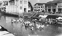
At the beginning of the 17th century, the area was controlled by Chinese and other native people who later had to submit to the Dutch East Indies.
In 1854, the Law of Comptabuliteit 1854 divided the Jakarta Bay area into three categories: the Voorsteden (the suburbs), Regentschap Batavia (the Regency of Batavia) and private areas (supervised by the Department of Security - Afdeling I) The government system changed again in 1905.
After the formation of the Unitary Republic of Indonesia on 17 August 1945, Jakarta Bay was divided into several administrative regions, namely Kawedanan Penjaringan, Tanjung Priok and Bekasi.
[1] The table also includes the number of administrative villages (kelurahan) in each district, and their names and post codes.