Metacomet Trail
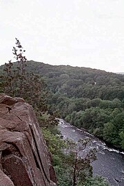
Despite being easily accessible and close to large population centers, the trail is considered remarkably rugged and scenic.
Notable features include waterfalls, dramatic cliff faces, woodlands, swamps, lakes, river flood plain, farmland, significant historic sites, and the summits of Talcott Mountain and the Hanging Hills.
[4] The Metacomet Trail extends from the Connecticut/ Massachusetts border south through Hartford and northern New Haven counties in Connecticut.
The southern terminus of the trail is located just east of the Hanging Hills on U.S. Route 5, 4 miles (6 km) north of the city of Meriden, in the town of Berlin, Connecticut; the northern terminus is located in the hamlet of Rising Corner, part of Suffield, Connecticut, 7 miles (11 km) southwest of Springfield, Massachusetts.
Site-specific activities enjoyed along the route include hunting, fishing, horseback riding, boating, bouldering, rock climbing (access), and swimming.
The Farmington River cuts through the ridgeline between Hatchet Hill and Talcott Mountain in the Tariffville Gorge (east of Simsbury).
Historic features along the trail include Old Newgate Prison museum and copper mine in East Granby; Heublein Tower on Talcott Mountain with expansive view of four states; the Hill-Stead museum in Farmington, Connecticut, notable for its French impressionist painting collection and gardens; and Hubbard Park of the Hanging Hills of Meriden, designed with the help of famous landscape architect Frederick Law Olmsted and crowned with a small observation tower known as Castle Craig.
[9] Viewshed from the ledges include agrarian land, suburbs, small towns, river corridors, the eastern Berkshires ridgeline, and metropolitan Meriden and Hartford.
[1] The Metacomet Trail passes through land located within the following incorporated towns, from south to north: Berlin, Meriden, Southington, New Britain, Plainville, Farmington, West Hartford, Avon, Bloomfield, Simsbury, East Granby, and Suffield, Connecticut[1][10] The Metacomet Ridge that forms the spine of the Metacomet Trail was formed 200 million years ago during the late Triassic and early Jurassic periods, and is composed of trap rock, also known as basalt, an extrusive volcanic rock.
Basalt is a dark colored rock, but the iron within it weathers to a rusty brown when exposed to the air, lending the ledges a distinct reddish appearance.
Huge slopes made of fractured basalt scree are visible beneath many of the cliffs along the Metacomet Trail.
[11] The Metacomet Ridge was the product of several massive lava flows hundreds of feet deep that welled up in faults created by the rifting apart of North America from Eurasia and Africa.
Erosion occurring between the eruptions deposited deep layers of sediment between the lava flows, which eventually lithified into sedimentary rock.
Backslope plant communities tend to be more similar to the adjacent upland plateaus containing species common to the northern hardwood and oak-hickory forest types.
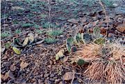
Because the Metacomet Ridge generates such varied terrain, it is the home of several plant and animal species that are state-listed or globally rare.
It received the Connecticut Governor's Green Circle Award yet was ignored by authorities in Southington, Berlin, New Britain, and Meriden.
[16] The name "Metacomet" was borrowed from the 17th century sachem of the Wampanoag Tribe of southern New England who led his people during King Philip's War.
[5] According to popular folklore, Metacomet, dubbed "King Phillip" by the English colonists, watched the burning of the village of Simsbury in 1676 from a cave on Talcott Mountain.
Hubbard elicited the assistance of notable landscape architect Fredrick Law Olmsted in drawing up the design.
Finished in 1900, it comprises approximately 1,800 acres (7.3 km2) of carefully kept woodlands, streams, dramatic cliff faces, flower gardens, and the James Barry bandshell and picnic spots.
[22] Will Warren's Den, a boulder cave located on the west side of Rattlesnake Mountain, is an historic landmark of the town of Farmington.
[1][9] The footway of the Metacomet Trail is maintained by volunteer efforts largely facilitated by the Connecticut Forest and Park Association.