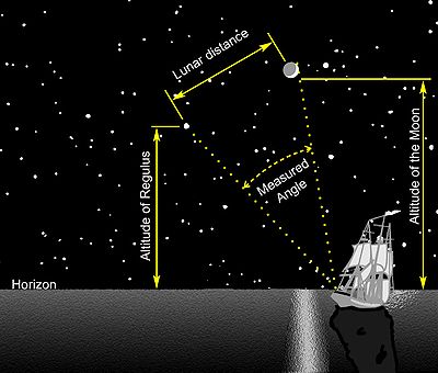
Lunar distance (navigation)
[2][3][4] After the method was first published in 1763 by British Astronomer Royal Nevil Maskelyne, based on pioneering work by Tobias Mayer, for about a hundred years (until about 1850)[5] mariners lacking a chronometer used the method of lunar distances to determine Greenwich time as a key step in determining longitude.
In one hour it will move approximately half a degree,[1] roughly its own angular diameter, with respect to the background stars and the Sun.
[1][7] By comparing the corrected lunar distance with the tabulated values, the navigator finds the Greenwich time for that observation.
Later sextants (after c. 1800) could indicate angle to 0.1 arc-minutes, after the use of the vernier was popularized by its description in English in the book Navigatio Britannica published in 1750 by John Barrow, the mathematician and historian.
Captain Joshua Slocum, in making the first solo circumnavigation of the Earth in 1895–1898, somewhat anachronistically used the lunar method along with dead reckoning in his navigation.
This was wonderful; both, however, might be in error, but somehow I felt confident that both were nearly true, and that in a few hours more I should see land; and so it happened, for then I made out the island of Nukahiva, the southernmost of the Marquesas group, clear-cut and lofty.
The work of the lunarian, though seldom practised in these days of chronometers, is beautifully edifying, and there is nothing in the realm of navigation that lifts one’s heart up more in adoration.
In his 1777 book, "A Voyage around the World", naturalist Georg Forster described his impressions of navigation with captain James Cook on board the ship HMS Resolution in the South Pacific.