Metropolitan Railway

Former Met tracks and stations are used by the London Underground's Metropolitan, Circle, District, Hammersmith & City, Piccadilly, Jubilee and Victoria lines, and by Chiltern Railways and Great Northern.

Costs were reduced by cutting back part of the route at the western end so that it did not connect directly to the GWR station, and by dropping the line south of Farringdon.

[18] Despite concerns about undermining and vibrations causing subsidence of nearby buildings[19] and compensating the thousands of people whose homes were destroyed during the digging of the tunnel,[20] construction began in March 1860.

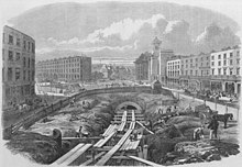
[16] The line was mostly built using the "cut-and-cover" method from Paddington to King's Cross; east of there it continued in a 728 yards (666 m) tunnel under Mount Pleasant, Clerkenwell then followed the culverted River Fleet beside Farringdon Road in an open cutting to near the new meat market at Smithfield.

[31] After minor signalling changes were made, approval was granted and a few days of operating trials were carried out before the grand opening on 9 January 1863, which included a ceremonial run from Paddington and a large banquet for 600 shareholders and guests at Farringdon.

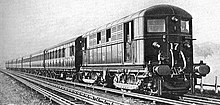
[32][37][l] The Metropolitan initially ordered 18 tank locomotives, of which a key feature was condensing equipment which prevented most of the steam from escaping while trains were in tunnels; they have been described as "beautiful little engines, painted green and distinguished particularly by their enormous external cylinders.

[43] With the problem continuing after the 1880s, conflict arose between the Met, who wished to make more openings in the tunnels, and the local authorities, who argued that these would frighten horses and reduce property values.

[33] The link to the West London Railway opened on 1 July that year, served by a carriage that was attached or detached at Notting Hill for Kensington (Addison Road).

A number of railway schemes were presented for the 1864 parliamentary session that met the recommendation in varying ways and a Joint Committee of the Parliament of the United Kingdom was set up to review the options.

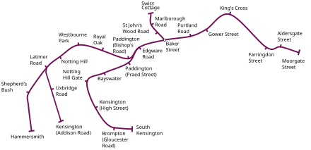
[68] Starting as a branch from Praed Street junction, a short distance east of the Met's Paddington station, the western extension passed through fashionable districts in Bayswater, Notting Hill, and Kensington.

[74] East of Westminster, the next section of the District's line ran in the new Victoria Embankment built by the Metropolitan Board of Works along the north bank of the River Thames.

Struggling under the burden of its very high construction costs, the District was unable to continue with the remainder of the original scheme to reach Tower Hill and made a final extension of its line just one station east from Blackfriars to a previously unplanned City terminus at Mansion House.

[33] In 1868 and 1869, judgements had been against the Met in a number of hearings, finding financial irregularities such as the company paying a dividend it could not afford and expenses being paid out of the capital account.

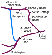
[108][y] To serve the Royal Agricultural Society's 1879 show at Kilburn, a single line to West Hampstead opened on 30 June 1879 with a temporary platform at Finchley Road.

[123] The Met took over the A&BR on 1 July 1891[123] and a temporary platform at Aylesbury opened on 1 September 1892 with trains calling at Amersham, Great Missenden, Wendover and Stoke Mandeville.

[87] In 1895, the MS&LR put forward a bill to Parliament to build two tracks from Wembley Park to Canfield Place, near Finchley Road station, to allow its express trains to pass the Met's stopping service.

[137] Because of the state of the relationship between the two companies the MS&LR was unhappy being wholly reliant on the Met for access to London and, unlike its railway to the north, south of Aylesbury there were several speed restrictions and long climbs, up to 1 in 90 in places.

A train scheduled to use the GWR route was not allowed access to the Met lines at Quainton Road in the early hours of 30 July 1898 and returned north.

[151] The use of six-car trains was considered wasteful on the lightly used line to Uxbridge and in running an off-peak three-car shuttle to Harrow the Met aroused the displeasure of the Board of Trade for using a motor car to propel two trailers.

Eventually the UERL controlled all the underground railways except the Met and the Waterloo & City and introduced station name boards with a red disc and a blue bar.

[168] Suggestions of merger with the Underground Group were rejected by Selbie, a press release of November 1912 noting the Met's interests in areas outside London, its relationships with main-line railways and its freight business.

[178][ah] In 1912, Selbie, then General Manager, thought that some professionalism was needed and suggested a company be formed to take over from the Surplus Lands Committee to develop estates near the railway.

[181] Published annually until 1932, the last full year of independence, the guide extolled the benefits of "The good air of the Chilterns", using language such as "Each lover of Metroland may well have his own favourite wood beech and coppice — all tremulous green loveliness in Spring and russet and gold in October".

[190] The generating capacity of the power station at Neasden was increased to approximately 35 MW[191] and on 5 January 1925 electric services reached Rickmansworth, allowing the locomotive change over point to be moved.

[195] A possible route was surveyed in 1906 and a bill deposited in 1912 seeking authority for a joint Met & GCR line from Rickmansworth to Watford town centre that would cross Cassiobury Park on an embankment.

After the London Passenger Transport Bill, aimed primarily at co-ordinating the small independent bus services,[212] was published on 13 March 1931, the Met spent £11,000 opposing it.

[213] The bill survived a change in government in 1931 and the Met gave no response to a proposal made by the new administration that it could remain independent if it were to lose its running powers over the circle.

[209] On 1 July 1933, the London Passenger Transport Board (LPTB), was created as a public corporation and the Met was amalgamated with the other underground railways, tramway companies and bus operators.

The traffic reduced significantly when the GCR introduced road transport to Marylebone, but the problem remained until 1936, being one reason the LPTB gave for abolishing the carrying of parcels on Inner Circle trains.

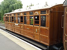
[260] After some derailments in 1887, a new design of 27 feet 6 inches (8.38 m) long rigid-wheelbase four-wheelers known as Jubilee Stock was built by the Cravens Railway Carriage and Wagon Co. for the extension line.

An engraving, titled at the top "The Metropolitan Underground Railway", showing a montage of outside views of the railway stations with people in Victorian dress travelling on foot or by horse. In the centre is an interior view of the original King's Cross station.
Montage of the Metropolitan Railway's stations from The Illustrated London News December 1862, the month before the railway opened
A middle aged Victorian gentleman sits beside a table wearing a dark suit with waistcoat and bow tie. His left elbow rests on the table. In his right hand he holds a quill pen.
Charles Pearson , promoter of underground railways for London
Drawing showing a road with buildings either side and a trench down the middle. The trench ends at a tunnel mouth, and is filled with wooden supports. Workmen and a horse are shown at work.
Construction of the Metropolitan Railway close to King's Cross station in 1861
drawing showing a large quantity of collapsed brickwork retaining wall and destroyed timber scaffolding alongside a flooded excavation. Beyond the cutting is a wide open area with small figures inspecting the damage. The backdrop is formed by a collection of two-storey buildings many of which have large chimneys.
The cutting at Farringdon following the flooding from the Fleet sewer in June 1862
Route diagram showing the railway as a purple line running from Paddington at left to Farringdon Street at right.
The railway as it opened in 1863
Metropolitan Railway A-Class 4-4-0T No 23 in Covent Garden
A curve from left to right shows the Metropolitan Railway and King's Cross, Farringdon Street, Aldersgate Street, and Moorgate Street stations. The Widened Lines are shown starting just before King's Cross and then following the Met, crossing over the line before reaching Farringdon, then continuing to Moorgate where they terminate. Junctions with the Widened Lines are shown near Kings' Cross linking to lines coming from the main line stations at King's Cross and St Pancras and between Farringdon and Aldersgate linking with a line going south through Snow Hill station.
The City Widened Lines between King's Cross and Moorgate Street and their connections. The east curve south to the LC&DR opened in 1871, the station at Snow Hill was opened in 1874.
The route is shown as a purple line from Moorgate on the right and drawn left to Paddington, were a branch is shown looping down and round to South Kensington. Left of Paddington another junction is shown at Latimer Road to Kensington before the route ends at Hammersmith.
The Metropolitan Railway in 1873, ten years after opening. Also shown is the Metropolitan and St John's Wood Railway from Baker Street to Swiss Cottage, which was operated by the Metropolitan Railway. The GWR operated the services between Kensington (Addison Road) and Moorgate.
A well-lit railway tunnel recedes into the distance. A train with a steam locomotive and carriages is heading towards the viewer but taking the branch off to the left.
A GWR broad gauge train is taking the route to Bishop's Road at Praed Street junction near Paddington, where the Notting Hill and Brompton extension joins the original line.
The railway line is in the shape of the letter C. The top of the C, between Kensington (High Street) in the west and Moorgate Street in the east, was run by the Metropolitan Railway, and the bottom of the C, between South Kensington and Mansion House, by the District. Between Kensington (High Street) and South Kensington the two railways overlap, the companies having their own track. Junctions with the Met are shown at Baker Street and east of Paddington and with the District near Earl's Court.
In 1871 the inner circle services began, starting from Mansion House and travelling to Moorgate Street via South Kensington and Paddington. The companies had their own pairs of track between Kensington High Street and South Kensington.
The joint railway is shown between Mansion House and Whitechapel. Continuing from an end-on junction with the District at Mansion House it passes through stations and as it passes Aldgate a junction allows access to the station before the line to continues east. When it reaches Whitechapel the line curves south to join the East London Railway.
In 1884, the line in blue completed the inner circle, providing access to the East London Railway for the Met and the District. The Met's station at the Tower of London was closed soon after the line was opened. District services were extended east of Whitechapel over the Whitechapel & Bow Railway in 1902. [ 88 ]
A map shows the joint Great Western route parallel to the Met's Route. A joint railway links the two at Aylesbury; a Great Central Railway links the two before Brill.
In 1906 the Great Central had two routes to London, by the Met via Amersham or the Great Central and Great Western Joint Railway via High Wycombe.
A three-quarter black-and-white photograph of a train standing at a station, showing the end carriage with windows at the end.
The jointly owned experimental passenger train that ran for six months in 1900
A map titled "London Underground Railways" showing each of the underground railway lines in a different colour with stations marked as blobs. Faint background detail shows the River Thames, roads and non-underground lines.
The joint U NDERGROUN D map published in 1908. The Metropolitan Railway is shown in red.
The headquarters of the railway were built at Allsop Place behind Baker Street station in 1913
A painting of a half-timbered house set behind a drive and flower garden. Below the painting the title "METRO-LAND" is in capitals and in smaller text is the price of two pence.
The cover of the Metro-Land guide published in 1921
A line is shown at the bottom, from right to left, with stations at Baker Street, Edgware Road and junction before two Paddington stations. From Baker Street a line is shown going north through several stations before turning left. From Edgware Road a line in a contrasting colour is shown, going north bypassing these stations before joining the line from Baker Street just north of Kilburn & Brondesbury.
A 1925 plan for a relief line from Kilburn & Brondesbury to Edgware Road to relieve the tunnels between Finchley Road and Baker Street
The coat of arms of the Metropolitan Railway, combining the arms of London, Middlesex, Buckinghamshire and Hertfordshire
A horse and cart stand in a street outside a narrow building with large open doors and a dark interior. A sign above the doors says "Metropolitan Railway Goods Depot".
The entrance to Vine Street depot in the 1910s
A black-and-white photograph of a 2-6-4 tank locomotive in three-quarter view. The side tank closest to the camera has the word "Metropolitan" painted on it.
One of six K Class 2-6-4 steam locomotives introduced to the Metropolitan Railway in 1925 to haul freight trains
Side view of a varnished wooden railway carriage with doors and windows at regular intervals down the side.
Metropolitan Railway Jubilee carriage No. 353 at Ongar station in July 2013
A black and white image of an electric locomotive hauling at least 6 coaches, shown with the electric locomotive on the right. A track in the foreground is electrified with the fourth rail system. The locomotive is shown with two pick-up shoes.
An electric locomotive and train on the Metropolitan Railway in the 1920s
A black and white image of an electric multiple unit on the furthest of four tracks.
A T stock multiple unit at Neasden