Milburn, Cumbria
[1] It lies beneath Cross Fell, the highest point of the Pennines and is one of a chain of villages following the 200 metres (660 ft) contour of the escarpment.
A number of businesses offering professional and construction services now operate in the village, and local non-agricultural work accounted for the employment of a further 20%.
The houses round the green present a continuous frontage broken only by narrow lanes giving access to the farmyards, barns and fields which lie behind.
Roads and tracks enter at the corners of the green and access is so restricted at some points that it has been suggested that the village has been constructed on defensive lines – possibly against the Border Reivers.
The church, together with the churchyard, occupies a neck of land bounded by two becks flowing in steep-sided ravines which contain several natural strong-running springs.
A second possibility for a site of settlement is the curious wiggle in Low Street at the point where the road from Newbiggin crosses to enter the outskirts of the present village.
Curiously on the edge of the road at the entrance to the lonning leading to the church at NY65360/29165 there is an ancient stone which is registered on the Sites and Monuments Record (SMR[10]) as a cross base.
Whatever the precise stimulus and the exact date of the migration of the village to its present site, it must have occurred in time to create the medieval field system.
Assuming, for the sake of romance at least, that the development was indeed planned, Butterworth[8] considers whether the modern arrangement of houses and farms round the central green took shape as a single act of concerted construction or, as would seem more likely, took place in a staged, "organic" fashion.
Re-orientation of properties to accord with the current layout would have taken place as houses were gradually improved and replaced and it was found convenient to regard the green as the centre of the village.
The modern "front gardens" of properties round the green were enclosed gradually over a number of years with the consent of the Lord of the Manor.
The subsequent waves of rebuilding which have resulted in the total eradication of the earlier medieval structures are easily explained by the parallel phases of development seen elsewhere in the county.
This sandstone underlies most of the Eden Valley and, in fact, runs right beneath the volcanic deposits of the Lake District to emerge eventually on the Solway coast, whence its name.
The soils also contain many rounded boulders of varying sizes which, because of their hardness provide a valuable building material to augment the softer, easily worked sandstone.
The larger boulders are frequently seen in use as building foundations, while the smaller cobbles are widely employed in the drystone field-walls which form another characteristic feature of the area.
Further to the north still, sandwiched between these intake fields and the steep slopes of the Pennine escarpment itself lies a complex geological zone known as the Cross Fell Inlier (see Burgess and Wadge[12]).
Nevertheless, the lower slopes of the inlier are still sufficiently valuable to be enclosed, largely with drystone walling, and are used for grazing sheep and cattle.
The old "commoner" system, whereby grazing (and other) rights were granted exclusively to individuals, has also been bought out by English Nature, concerned about the effect of over-grazing.
English Nature is also attempting to develop the diversity of the fell side habitat and has planted selected areas with hardy indigenous species such as juniper.
A typical site situated just above the Middle Tongue Beck at NY 692/321 is known as the New Greuve Shop and seems to have yielded a variety of minerals ranging from coal to lead.
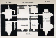
Howgill Castle is a fortified manor house lying approximately 1 km to the east of the main village and at a slightly higher elevation.
Although Pevsner[13] considers the sandstone masonry of the chancel to be Norman, it is claimed that the body of St Cuthbert rested here in 876 when monks from Lindisfarne fleeing the Viking invaders toured the county bearing the holy relics of their saint with them.
The site, with its secluded position above the deep ravine of Stank Beck and its association with nearby strongly-flowing springs is extremely difficult to interpret.
Following the departure of the Romans, the Saxons built churches for Christian worship, and the present structure contains re-used stones, some with sundial markings, which can be seen arranged haphazard in the masonry.
In the seventeenth century, Sir Richard Sandforth of Howgill extended the south side and put a third window there in memory of his wife Anne.
The east window was redesigned and revealed a coffin lid dated c.1300 used as a memorial to a one time Rural Dean, with shears to cut the tonsure of the priesthood.
The maypole erected in 1995 at the expense of the Lord of the Manor displayed a pronounced lean which may have been due to the fact that it was struck by lightning shortly after its installation.
According to Butterworth[8] there has been a school in the village since at least the 18th century and the present building was constructed in 1851 replacing an earlier, thatched one which was burnt down by one of the pupils in 1850.
For car users this poses little difficulty (as long as fuel remains affordable) but for non-drivers the lack of public transport is a serious concern.
A county-supported car scheme subsidises the mileage-costs of local volunteers who donate their time freely to provide transport to shops and doctors surgeries etc.