Mill Valley, California
Beyond the flat coastal area and marshlands, it occupies narrow wooded canyons, mostly of second-growth redwoods, on the southeastern slopes of Mount Tamalpais.
As of 2011, there are over 1,000 registered members of the Federated Indians of Graton Rancheria, which includes both the Coast Miwok and the Southern Pomo, all of whom can date their ancestry back to 14 survivors as original tribal ancestors.
[14] The village site was first identified by Nels Nelson in 1907, and his excavation revealed tools, burials and food debris, among other things, just beyond the driveway of a residence on Locust Ave. At that time, the mound was 20 feet (6.1 m) high.
At the mission, they were taught the Catholic faith, lost all of their known freedom, and over three-quarters died as a result of exposure to foreign diseases, to which the Native Americans lacked immunity.
That same year, the governor of Alta California, José Figueroa, awarded to John T. Reed the first land grant in Marin, Rancho Corte Madera del Presidio.
He built the first sawmill in the county on the Cascade Creek (now Old Mill Park) in the mid-1830s on Richardson's rancho and settled near what is now Locke Lane and LaGoma Avenue.
The rest of the rancho, including the part of what is now Mill Valley that did not already belong to Reed's heirs, was given to his administrator Samuel Reading Throckmorton.
It was Richardson's territory that would soon become part of Mill Valley when Throckmorton's daughter Suzanna was forced to relinquish several thousand acres to the San Francisco Savings & Union Bank to satisfy a debt of $100,000 against the estate in 1889.
[21] In 1873, San Francisco physician Dr. John Cushing discovered 320 "lost" acres between the Reed and Richardson boundaries between present-day Corte Madera Avenue, across the creek, and into West Blithedale Canyon.
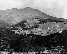
[22] Fishing, hunting, hiking, swimming, horseback riding, and other activities increased in popularity as people came to the area as vacationers or moved in and commuted to San Francisco for work.
[17] The Tamalpais Land & Water Co. hired Michael M. O'Shaughnessy, already a noted engineer to lay out roads, pedestrian paths, and step-systems for what the developers hoped would become a new city.
Harvey A. Klyce was one of the most prominent of the architects and designed many private homes and public buildings in the area, including the Masonic Lodge in 1904.
[24] Before his death in 1894, Eastland built a large summer home, "Burlwood", constructed on Throckmorton Avenue in 1892 that still stands though much of the original land has been parceled off.
[25] Janes, by then the resident director of Tamalpais Land & Water Co. (and eventually the city's first town clerk), and Sidney B. Cushing, president of the San Rafael Gas & Electric Co. set out to bring a railroad up Mt.
Tamalpais Scenic Railway opened in 1896 (with Cushing as president) and ran from the town center (present-day Lytton Square) all the way to the summit.
Tamalpais & Muir Woods Scenic Railway, "The Crookedest Railroad in the World" and its unique Gravity Cars[26] brought thousands of tourists to the Tavern of Tamalpais on the mountain summit (built in 1896, rebuilt after the 1923 fire, and razed in 1950 by the California State Parks),[27] the West Point Inn (built in 1904, by the scenic railway, operated commercially until 1943, closed briefly and then run by volunteers to the present day),[28] and the Muir Woods Inn (burned in 1913, rebuilt in 1914, destroyed in 1930).
This occurred as a result of a drop in ridership due to increased usage of automobiles rather than trains for recreation and construction of the Panoramic Highway and connecting road to Ridgecrest in 1929.
Workers commuted to San Francisco on the Greyhound bus when the streets were not flooding in heavy rain,[citation needed] and there still were not any traffic lights.
Mill Valley became an area associated with great wealth, with many people making their millions[citation needed] in San Francisco and moving north.
Cascade Dam, built in 1893, was closed in 1972 and drained four years later in an attempt to curb the "hordes"[citation needed] of young people using the reservoir for nude sunbathing and swimming.
In addition, there are many municipally maintained open-space reserves, parks, and coastal habitats which, when taken together, ensconce Mill Valley in a natural wilderness.
These are undeveloped natural areas and contain many species of wild animals, including some large predators like the coyote, the bobcat, and the cougar.
[48] Mill Valley is also affected by microclimate conditions in the several box canyons with steep north-facing slopes and dense forests which span the southern and western city limits, which, along with the coastal fog, all conspire to make many of the dense forested regions of Mill Valley noticeably cooler and moister, on average, than other regions of town.
This microclimate is what makes for the favorable ecology required by the Coastal Redwood forests which still cover much of the town and surrounding area, and have played such a pivotal role throughout the history of Mill Valley.
[54] The combination of Mill Valley's idyllic location nestled beneath Mount Tamalpais coupled with its relative ease of access to nearby San Francisco has made it a popular home for many high-income commuters.
[57] While Mill Valley has retained elements of its earlier artistic culture through galleries, festivals, and performances, its stock of affordable housing has diminished,[58] forcing some residents to leave the area.
As of April 2007, only one affordable housing project was underway: an initiative to renovate and expand a century old but now abandoned local landmark roadhouse and saloon called the Fireside Inn.
North Bridge Academy, a private school located in downtown Mill Valley, serves 2nd - 8th grade students with dyslexia.
The municipal library overlooks Old Mill Park and provides many picturesque reading locations, as well as free computer and Internet access.
[64] As part of the City of Mill Valley's decision to "go Green", the library has a Sustainability Collection with books and DVDs with information about how to become more environmentally friendly.