Misamis Oriental
The Fuerza de la Concepcion y del Triunfo in Ozamiz was built as a Spanish military installation and one of the staging points in their expeditions against Moros.
A fort in Balo-i in present-day Lanao del Norte was also constructed in 1891 on the orders of General Valeriano Weyler in its renewed campaign against the Maranaos.
The Fuerza de San Miguel in Iligan was also built, serving as a muster point for Spanish forces in their campaigns in Lanao.
[citation needed] In 1942, at the onset of World War II in the Philippines, Japanese soldiers landed in Misamis Oriental to occupy the region.
[citation needed] Filipino and American resistance guerrillas operated in the hills and forests of Misamis Oriental and Bukidnon, and both provinces fell under the jurisdiction of the 10th Military District commanded by Col. Wendell Fertig.
[17] During this time, Initao, Misamis Oriental was the site of the Holy Temple of Power of the Christian settler cult named Sagrado Corazon Senor (Sacred Heart of the Lord), which became better known as Tadtad (literally "to chop") because of their violent actions, and was one of numerous cults tapped by Marcos' military as force multipliers in their efforts against the Muslim secessionists and the communists.
[18] In September 1972, Marcos was nearing the end of this last term allowed under the Philippines 1935 constitution when he placed the entirety of the Philippines under Martial Law, a period historically remembered for its human rights abuses, [19][20] particularly targeting political opponents, student activists, journalists, religious workers, farmers, and others who fought against the Marcos dictatorship.
[21] Only about 170 survivors from Northern Mindanao - including Misamis Oriental - were fortunate to live long enough to receive legally mandated compensation in the mid-2010s.
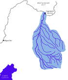
When the independent city of Cagayan de Oro is included for geographical purposes, the province's land area is 3,544.32 square kilometres (1,368.47 sq mi).
[28][29] A study by the Mindanao State University attributes the biodiversity on Mount Sumagaya to the Indigenous management strategy and sustainable agriculture practiced by the Higaonon.
[28] Mount Sumagaya hosts at least 52 floral species from 19 families, including many that are considered economically and socially significant to the Higaonon people.
The rest of the residents are native Higaonons, Binukid, Manobos (who became minorities in their own homeland because of the non-native Visayan majority) and neighboring Subanens (native to neighboring provinces of Misamis Occidental, parts of Lanao del Norte and northern parts of Zamboanga Peninsula), as well as Maranaos, Maguindanaons, and Tausugs and other Christian settlers (and their native-born descendants) from Ilocandia, Cagayan Valley, Cordillera Administrative Region, Central Luzon, Calabarzon, Mindoro, Marinduque and Bicolandia in Luzon, and Panay and Negros Occidental in Visayas who came during the late Spanish colonial period and since the American colonial and postwar eras.
These non-native settlers are informally called Dumagats, from the root word "dagat" (literally means "sea" or "ocean") because they dwell among the province's coastline upon landing from Luzon and Visayas by boats or later by ships, causing indigenous Higaonons to relocate to the mountains to avoid contact with these newcomers.
Other languages that may be heard varyingly in the province include the native Binukid, Higaonon, Subanon, as well as Hiligaynon, Ilocano, Kapampangan, Maguindanaon and Tausug.
Other Christian denominations compose most of the minority religions that forms 9% of the population with 28% belongs to Iglesia Filipina Independiente (IFI or Aglipayan Church).
[citation needed] Poverty Incidence of Misamis Oriental Source: Philippine Statistics Authority[32][33][34][35][36][37][38][39] The province is host to industries such as agricultural, forest, steel, metal, chemical, mineral, rubber and food processing.