Mississippi River System
This system of waterways is maintained by the U.S. Army Corps of Engineers with a project depth of between 9–12 ft (2.7–3.7 m) to accommodate barge transportation, primarily of bulk commodities.
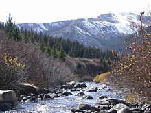
[7] The Upper Mississippi River spans around 1,250 miles (2,010 km) from Lake Itasca in Minnesota to Cairo, Illinois.
[8] Most of the Upper Mississippi goes through the center of the Driftless Area, around 15,000 sq mi (39,000 km2) in Minnesota, Wisconsin, Iowa, and Illinois that has managed to stay free of glacial flows covering the past two million years.
[9] The Driftless Area is defined by a multitude of limestone bluffs that have been molded all the way since the last ice age, due to water melting from glaciers.
The bottom of the river is composed of a thin layer of clay, silt, loam, and sand, which lay above a stratum of glacial outwash.
[12] This river was important among Native Americans and early French traders as the principal water route connecting the Great Lakes with the Mississippi.
The Illinois River meets the Mississippi at Pere Marquette State Park, which is near Grafton.
The Missouri River was one of the main routes for the westward expansion of the United States during the 19th century.
[11] It originates right outside of the Rocky Mountains and stretches through multiple states with the main portion of it located in Texas.
The river is important for commerce because it shortens the distance to the Gulf of Mexico, also saving companies time and money.
The silts deposited by the water made the surrounding areas very desirable and an ideal place to farm due to the extremely fertile location.
Mark Twain is regarded as having a large impact on molding U.S. literature into what it is today because of his profound works on adventures and life on the rivers.
[20] Today, the Mississippi River System, along with its connecting tributaries, is primarily used for transporting agricultural and manufactured goods across the span of the country.
Some common things that are shipped include petroleum, iron, steel, grain, rubber, paper, wood, coffee, coal, chemicals, and edible oils.
Many years after this, the land continued to be molded into the Mississippi River System due to the overflowing of water from nearby oceans, causing constant flooding.
Around two million years ago, glaciers up to 1.2 miles (1.9 km) thick continued to disturb the environment.
The receding formation of glaciers 15,000 years ago, at the end of the last ice age, left large amounts of water in North America, which created the rivers.
[22] The Mississippi River stemmed from Lake Itasca in northern Minnesota where it was only a tiny outlet stream.
Forty percent of the United States' migratory waterfowl use the Mississippi River corridor during the Spring and Fall migration.
Sixty percent of all North American birds (326 species) use the river Basin as their migratory flyway.
[29] In 1993, the Mississippi River flood devastated seventeen thousand square miles of land, spanning across nine states.
Twenty percent of the population that surrounded the flood area have since left due to economic hardship or personal troubles.
[30] The Army Corps of Engineers currently oversees all the responsibilities of making sure the rivers are best maintained to avoid more flooding.


In late 2022 there was low river levels that caused two backups on the Lower Mississippi River that held up over 100 tow boats with 2,000 barge units and caused barge rates to soar [ 23 ] [ 24 ]

