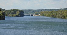
Mohawk River
The Mohawk flows into the Hudson in Cohoes, New York, a few miles north of the state capital of Albany.
In Hillside is the confluence of Lansing Kill, after which it flows towards the Hamlet of North Western receiving Stringer Brook along the way.
The Gilboa Dam, which was completed in 1926 as part of the New York City water supply system, is the subject of an active and aggressive rehabilitation project.
Much of the main trunk of the Mohawk River sits in Cambro-Ordovician carbonates (limestone) and Middle Ordovician sandstones and shales.
[19] In this final phase, the enormous discharge of water caused local deep scour features (e.g. the Potholes at Little Falls), and extensive sand and gravel deposition, which is one of the key sources of municipal groundwater including the Scotia Delta, which is also known as the Great Flats Aquifer.
Their territory ranged north to the St. Lawrence River, southern Quebec and eastern Ontario; south to greater New Jersey and into Pennsylvania; eastward to the Green Mountains of Vermont; and westward to the border with the Iroquoian Oneida Nation's traditional homeland territory.
The first recorded European exploration of the Mohawk was a trip by the Dutchman Harman Meyndertsz van den Bogaert in 1634.
[24] In 1661 Dutch colonists founded the city of Schenectady on the Mohawk River approximately 19 miles (31 km) from Albany.
"[25] In 1712 the British, now in control of New York, built Fort Hunter at the confluence of the Mohawk and the Schoharie Creek, about 22 miles (35 km) upriver from Schenectady.
Swedish explorer and botanist, Pehr Kalm, visited the area along the river in the mid-18th century where he encountered some of the indigenous peoples belonging to the Iroquois confederacy, and has left a record for posterity of some of their customs in his journal.
[29] Much of the water flows through the watershed in the spring as snow melts rapidly and enters the tributaries and the main trunk of the river.
For the period between 1917 and 2000, the highest mean daily flow is c. 18,000 cu ft (510 m3) as measured at Cohoes, near the confluence with the Hudson.
[33] The Mohawk River also saw significant flooding during the weeks between August 21, 2011, and September 5, 2011, due to torrential rains experienced from Hurricane Irene and Tropical Storm Lee.
On July 3, 1985, Congress approved a project at Amsterdam for work to be done on the Mohawk River and South Chuctanunda Creek.
A new wing wall was installed on the left bank of South Chuctanunda Creek at the upstream end of the New York Central Railroad Bridge.
In July 2012, governor Cuomo announced a project to improve the flood walls on South Chuctanunda Creek and Mohawk River.
[37] This plan identifies five priority goals for the Mohawk River Basin that are designed to enhance ecosystem health and the vitality of the region.
The Action Agenda, developed by the NYS DEC in collaboration with a number of stakeholders in the basin with public input, advocates an ecosystem-based approach to watershed management.
[38] In October 2014, Riverkeeper, an environmental advocacy and clean water watchdog organization, announced that they will be expanding the reach of their efforts from the Hudson River to the Mohawk as well.