Isla de Mona
[2] There are no permanent inhabitants; only rangers and biologists from the Puerto Rico Department of Natural and Environmental Resources reside on the island, to manage visitors and take part in research projects.
Within hours of setting foot in Puerto Rico, Columbus and his ships headed west to Hispaniola, where he expected to meet several crewmembers who had remained behind from his first voyage.
Due to its small size and location, the island proved inadequate to accommodate such a large settlement, and food became scarce as shipments from Hispaniola and Puerto Rico were received infrequently.
By 1524, Alonso Manso, bishop of Puerto Rico, had become interested in gaining personal wealth, and he accused Barrionuevo, among others, of various crimes under the Spanish justice system of the time.
By 1522, ships from other major sea powers such as England, France, and the Netherlands began to arrive at Isla de la Mona to replenish supplies for their transatlantic voyages.
In 1561, during an audience held in Santo Domingo, it was recommended that Isla de la Mona should become a part of that colony (which at the time occupied the entirety of Hispaniola).
The reasons offered were simply that the island was closer to Santo Domingo (presently the Dominican Republic) than to Puerto Rico, and that it had a small population which could help the colony's economy in overall agricultural production.
However, by this time most Taínos remaining on the island had either died or fled to mainland Puerto Rico due to repeated raiding by European (especially French) ships.
Various companies were granted licenses to extract the bat and seagull guano (a valuable fertilizer and key strategic commodity for the production of gunpowder) from the island's caves.
[11] With the 1898 Treaty of Paris, Isla de la Mona, along with the rest of Puerto Rico, was handed to the United States by Spain.
In 1923, a stash of liquor, drugs, and perfumes, reportedly from the French islands of Martinique and Saint Martin and worth US$75,000, was found in a cave by customs officials.
Prior to this, the Nazi U-boat had sunk nineteen ships in the region including one named Del Plata in Puerto Rican waters.
In 1960 a small ranger post was established to monitor the island, operated by the Puerto Rico Department of Natural and Environmental Resources.
In July 1972 the Puerto Rico Environmental Quality Board, because of growing interest in the development of the islands, made a full scientific assessment of Mona and Monito using a local team of volunteer scientists.
Shortly thereafter geotechnical and bathymetric studies were conducted by engineering firms to determine the feasibility of using Mona as a deep-water terminal for transferring oil from supertankers to smaller tankers which would continue to the mainland US; this plan was never implemented.
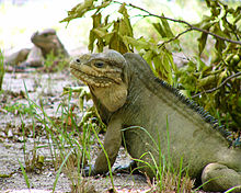
With an arid climate and untouched by human development, many endemic species inhabit the island, such as the Mona ground iguana (Cyclura cornuta stejnegeri).
Four types of land cover can be identified:[24] Mona Island hosts a large and increasing hawksbill sea turtle (Eretmochelys imbricata) rookery with over 1,500 clutches laid annually on its beaches.
The island is recognized as one of the principal sites for hawksbill nesting in the Wider Caribbean and Western Atlantic region, along with Mexico (Yucatán Peninsula beaches), Barbados, Panama (Bocas del Toro), and Brazil.
The United States Coast Guard is able to provide transportation with helicopter flights from Rafael Hernández Airport in Aguadilla, to help with medicines and first aid equipment; they also fly whenever an emergency requiring hospitalization occurs.
Private and commercial planes require a special permit issued by the Puerto Rico Department of Natural Resources to use the airport's facilities.
The most common form of transportation is by private yacht, though commercial excursions are available from Cabo Rojo for small groups of up to twelve people traveling together.
In recent years, the island has become a major drop-off point especially for Dominicans, as well as Haitians and Cubans trying to reach Puerto Rico illegally.