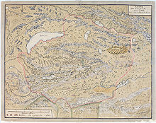
Mongolian manuscript maps
They gave a bird's eye view of the area depicted, making them somewhat similar to pictorial maps.
Although the roots of Mongolian cartography are probably older, the manuscript maps known today were all produced after 1690, when the Lifanyuan in Beijing ordered all Mongolian nobles to produce maps of their territory.
The maps show major geographic features, and give the positions of those (usually 24 or 48) ovoos that marked the border.
[1] Mongolian manuscript maps were first brought to the attention of European scientists by August Strindberg, who in 1878 wrote an article about Dzungarian maps brought to Sweden by Johan Gustaf Renat.
[2] Old Mongolian maps also played a role in the Japanese claims about the western border of Manchuguo in the run-up to the Battle of Khalkhin Gol.