Montmorency River
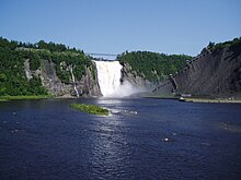
Thereafter, it passes through the municipalities of Sainte-Brigitte-de-Laval, Beauport, and Boischatel, where the course of the river is characterized by the presence of numerous rapids before plunging 83 metres (272 ft) over the Montmorency Falls.
The largest lake, with an area of 7.53 square kilometres (2.91 sq mi), is Lac des Neiges (English: Lake of Snow) which is the source of rivière des Neiges (English: River of Snow), Montmorency's largest tributary.
Urban and agricultural land makes up only 2% and 1% of the basin respectively, and is mostly confined to a small section in the far south of the Saint Lawrence lowlands.
The name of the falls came to be applied to the whole river, as the 1641 map by Jean Bourdon showed it as "Saut de Montmorency".
The river was used for log driving and its shores became industrialized when a hydro-electric dam and sawmill were built at the top and foot of the Montmorency Falls respectively.
[1] In 1992, the area surrounding the falls and mouth of the river was made into a park and developed for tourism with new viewing platforms, stairs, pedestrian bridge, aerial tram, restaurant, and visitor's centre.
Of these, only 3 are public road bridges: Quebec Route 40, Avenue Royale between Beauport and Boischatel, and one at Enchanteresse Island.
[6] The toponym "Montmorency river" was formalized on December 5, 1968 at the Commission de toponymie du Québec.