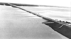
Morganza Spillway
The spillway and adjacent levees also help prevent the Mississippi from changing its present course through the major port cities of Baton Rouge and New Orleans to a new course down the Atchafalaya River to the Gulf of Mexico.
The Corps of Engineers considers opening the Morganza Spillway when the flow of the Mississippi at Red River Landing, Louisiana,[12][13] is greater than 1,500,000 cu ft/s (42,000 m3/s) and rising.
During the 1973 Mississippi flood, the ORCS was being damaged due to high flow rates, leading to the opening of the Morganza Spillway to help relieve this pressure.
Subsequently, the nearby Old River Control Auxiliary Structure (ORCAS) was constructed, adding additional floodgates for use during major floods.
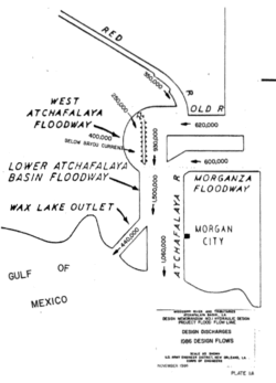
[1] From there, diverted water enters the Atchafalaya River Basin Floodway near Krotz Springs, Louisiana,[1] and continues to the Gulf of Mexico.
Inhabitants know that the region is a natural floodplain, and the Corps of Engineers issues written notices annually to all interests reminding them of the possibility that it might open the spillway and flood the area.
Part of that planning process includes the Corps' preparation of maps known as "inundation scenarios" so that interested parties can discuss how much water, if any, should be allowed through the spillway.
[1][15][16][17][18][19][20][21][22] During both moderate and severe floods of the Mississippi, the Bonnet Carré Spillway can also be opened to help protect New Orleans, many parts of which are below sea level.
Integrity of the Morganza Spillway, the Old River Control Structure, and nearby levees is essential to prevent the Mississippi from diverting its main channel into the Atchafalaya Basin.
On April 17, 1973, in order to lower the water level of the Mississippi River and relieve pressure on the Old River Control Structure, the Corps of Engineers opened 42 of the 125 steel gates of the Morganza Spillway for the first time since its completion, allowing about half of its maximum designed flow rate to pass from the Mississippi into the Atchafalaya Basin.
[27] During the Great Mississippi and Missouri Rivers Flood in 1993, officials decided to leave the gates of the Morganza Floodway closed.
However, additional rainfall raised the flood crest higher than even the supplemental sandbags, sending floodwaters over these levees into 3,000 acres (1,200 ha) of cropland located within the floodway.
The Corps studied four flooding scenarios, all of which assumed the Bonnet Carré Spillway would be concurrently operating at full capacity (100%).
Following this analysis, which showed that extensive flooding was expected in the Atchafalaya Basin regardless of the choice made regarding the Morganza Spillway, the Corps decided to start the 2011 diversion by opening the spillway a bit less than described in scenario 1a (21%, not 25%)[36] The Governor of Louisiana, Bobby Jindal, had meanwhile sent a letter on May 4, 2011, to Robert Gates, the United States Secretary of Defense, requesting that the National Guard be deployed under Title 32 of the United States Code status to respond to record water levels in Louisiana, where there was "a significant probability that the U.S. Army Corps of Engineers [would] open the Morganza Spillway for the first time since 1973.
Diversion of 125,000 cubic feet per second (3,500 m3/s) of water from the Mississippi River to the Atchafalaya Basin was planned during this event, with the structure operating at about 21% of its capacity.
[43] However, the US Army Corps of Engineers New Orleans issued a press release on May 30, 2019, announcing the postponement of the Spillway opening until June 6, 2019.