Mount Cleveland (Alaska)
Mount Cleveland is located 490 km (304 mi) from the western end of the Aleutian Arc,[4] a long volcanic chain extending off the coast of Alaska.
As the plate moves deeper into the earth, the increasing pressure results in the loss of volatiles, certain elements and compounds with low boiling points, from various hydrous minerals.
[9] Aleut oral tradition states that, at one time, the western and eastern halves of Chuginadak were separate islands, and that the isthmus joining them was created by volcanic activity sometime in prehistory.
[11] Its current name, Mount Cleveland, was given to it by a United States Coast and Geodetic Survey expedition in 1894, when it was originally observed by the USS Concord.
[14] Like many other Aleutian volcanoes, Cleveland's flanks are especially rough up to 300 m (984 ft),[15] covered by multiple overlapping lava flows and debris fans that form an apron around the mountain.
[9] Although Mount Cleveland is the tallest mountain in the group, it is rarely completely snowed in because of its constant activity disrupts snowfall.
[9] All known events have occurred at Mount Cleveland's summit vent,[4] but there are at least five small andesite to dacite volcanic domes on the lower flanks.
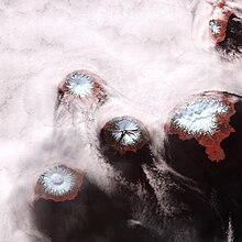
[4] The eastern half of Chuginadak, to which Mount Cleveland is connected by a narrow isthmus, consists of several low-lying volcanic cones[1] and two prominent peaks[16] that have been heavily eroded, partly by glaciers.
Little is known about Cleveland's early eruptive history as its remoteness makes it a difficult area to investigate, and discrepancies in names have caused confusion between events there and those on nearby Carlisle.
This plume dispersed 120 to 150 km (75 to 93 mi) across Alaska, an unusual distance that allowed detailed satellite observations to be made.
[23] A field study was conducted in late 2001,[14] and an automatic system based on thermal anomalies was implemented following eruptive events in 2005.
[23] In recent years the Alaska Volcano Observatory has made an effort to expand volcanic coverage westward along the Aleutian Arc.
[24] The biggest threat posed by an eruption from Mount Cleveland is its ash plume, which can damage sensitive electronic equipment on overflying planes.
Many aircraft traveling over the North Pacific and over the Arctic come within the vicinity of such a plume; the only way to avoid damage is to reroute the flight, which delays arrival time and adds $5,500 to $6,000 in extra fuel costs.
[4] Cleveland has therefore been assessed by the United States Geological Survey as "a volcano with a high aviation threat score and no real-time ground based monitoring at the present time".