Hekla
In the Flatey Book Annal it was recorded that during the 1341 eruption, people saw large and small birds flying in the mountain's fire which were taken to be souls.
The most active part of this ridge, a fissure about 5.5 km (3.4 mi) long named Heklugjá [ˈhɛhklʏˌcauː], is considered to be within Hekla proper.
A Unless otherwise stated eruption dates in Year (2019 values) column are from Global Volcanism Program and Catalogue of Icelandic Volcanoes,[4][27] As other sources can disagree,[23][25] there has been a recent literature update.
[24] Hekla 3, 4, and 5 produced huge amounts of rhyolitic ash and tephra, covering 80% of Iceland[28] and providing useful date markers in soil profiles in other parts of Europe such as Orkney,[29] Scandinavia,[9] and elsewhere.
[31] During the last 7,000 years, one third of the volcanic ash deposited in Scandinavia, Germany, Ireland, and the United Kingdom originated from Hekla.
[32] Hekla had been dormant for at least 250 years when it erupted explosively in 1104 (probably in the autumn), covering 55,000 km2 (21,000 sq mi) which is over half of Iceland with 1.2 km3[31] / 2.5 km3[33] of rhyodacitic tephra.
[36] A small eruption (VEI-3) started on 19 May and deposited around 5×10⁷ km3 (1.2×10⁷ cu mi) of tephra over the areas west and southwest of Hekla, leading to many cattle deaths, probably mainly from fluorosis.
During the eruption up to 0.5 m (1 ft 8 in) lava bombs were thrown 15–20 km (9.3–12.4 mi) away, and flooding was caused by the sudden melting of snow and ice on Hekla's slopes.
Then, with a tremendous crash, there were formed in the sides of the cone two large openings, whence there gushed torrents of lava, which flowed down two gorges on the flanks of the mountain.
The neighbouring rivers became so hot as to kill the fish, and the sheep fled in terror from the adjoining heaths, some being burnt before they could escape.
The tephra deposition of a total amount of 0.17 km3 (0.041 cu mi) was mainly to the east-southeast; immediately to the east of Hekla the layer was 20–40 cm (7.9–15.7 in) deep.
Large quantities of dark ash were deposited over pasture in the same directions leading to many livestock deaths through fluorosis for the next two years.
The eruption produced around 3 ML (110×10^3 cu ft) of water (snowmelt and directly from the fissure) which caused flooding of the Ytri Rangá river.
On 3 May, the volcano stopped throwing out lava in sudden explosions from its craters and changed to continuously ejecting tephra and ash for long periods, until early June when this reduced.
This, and other measurements, showed the area covered was long and narrow with the 1 mm contour (an equivalent of 8 tonnes per hectare) extending to the north coast.
Lava was initially produced from close to the summit, spreading to other parts of the fissure and covering an area of 22 km2 (8.5 sq mi) in around 24 hours.
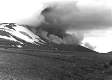
The eruption threw ash to a height of 6.6 km (4.1 mi), and a new crater formed at the summit from which 3 lava flows originated.
The eruption then began producing andesitic lava, the flows eventually covering an area of 23 km2 (8.9 sq mi) to an average depth of 6–7 m (20–23 ft).
The steam column rose to a height of almost 15 km (9.3 mi), and ash was transported to Grímsey on the North coast of Iceland.
In January 2003, however, a team from the Norvol Institute in Reykjavík, under the leadership of Dr. Ármann Höskuldsson, reported that they found traces of a pyroclastic flow, roughly 5 km long, stretching down the side of the mountain.
This will call for a reappraisal of volcanic eruptions of the basic rock type, which up to now were generally thought not to produce large pyroclastic flows.
Forest and some grasses are much more resilient to ash and pumice fall than low vegetation, but the combined effect of human habitation and the volcanic activity has left an unstable surface very susceptible to erosion.
Hekluskógar, a 90,000 ha (220,000 acres) reforesting project is attempting to restore the birch and willow woodland to the slopes of Hekla, starting with soil fertilisation and grass sowing.
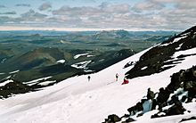
The volcano can be reached using the buses to Landmannalaugar 30 km (19 mi) further east, and it is possible to stay or camp at farms in the area.
In the Spanish apocalyptic science fiction film, Los Últimos Días (2013), some news reporters speculate that three recent eruptions of Mount Hekla could have caused the spreading form of agoraphobia that kills affected people who go outside.
In the Boston, Massachusetts area, Hekla pastries can be found – large, upside-down cinnamon rolls with white sugar icing spooned over the top to look like the snow-topped volcano.
[61] In To Lie With Lions, by Dorothy Dunnett, a party of merchants visiting Iceland in the year 1471 witnesses the spectacular (fictional) eruption of both Hekla and Katla.
The piece Hekla, Op 52 (1964) by Icelandic composer Jón Leifs, has been called the "loudest classical music of all time".
The requirements for a performance of Hekla include four sets of rocks hit with hammers, steel plates, anvils, sirens, cannons, metal chains, choir, a large orchestra, and organ.
There have been several ships of the Royal Navy named HMS Hecla In October 2011 a German left-wing militant group called the Hekla-Empfangskomitee (Hekla Reception Committee) set at least 17 incendiary devices on railways in the Berlin area, with 2 of them going off.