Mount Pinatubo
Located on the tripoint of Zambales, Tarlac and Pampanga provinces,[5][6] most people were unaware of its eruptive history before the pre-eruption volcanic activity in early 1991.
[7] The eruption coincided with Typhoon Yunya making landfall in the Philippines, which brought a dangerous mix of ash and rain to nearby towns and cities.
It released roughly 10 billion tonnes (1.1×10¹⁰ short tons) or 10 km3 (2.4 cu mi) of magma, bringing large amounts of minerals and toxic metals to the surface.
Mount Pinatubo and the other volcanoes on this volcanic belt arise due to magmatic occlusion from this subduction plate boundary.
[16] Pinatubo is flanked on the west by the Zambales Ophiolite Complex, which is an easterly-dipping section of Eocene oceanic crust uplifted during the late Oligocene.
The Tarlac Formation north, east and southeast of Pinatubo consists of marine, nonmarine and volcanoclastic sediments formed in the late Miocene and Pliocene.
Some of the nearby peaks are the remnants of ancestral Pinatubo, left behind when the softer parts of the old mountain slopes were eroded by weathering.
[17] The volcano has never grown very large between eruptions, because it produces mostly unwelded, easily erodible deposits and periodically destroys the viscous domes that fill its vents.
After the Buag eruption (c. 1500 AD), the volcano lay dormant, its slopes becoming completely covered in dense rainforest and eroded into gullies and ravines.
However, on June 12, millions of cubic yards of gas-charged magma reached the surface and exploded in the reawakening volcano's first spectacular eruption.
[7] When even more highly gas-charged magma reached Pinatubo's surface on June 15, the volcano exploded in a cataclysmic eruption that ejected more than 5 km3 (1.2 cu mi) of material.
[7] Huge pyroclastic flows roared down the flanks of Mount Pinatubo, filling once-deep valleys with fresh volcanic deposits as much as 200 m (660 ft) thick.
[22] On July 10, 2002, the west wall of the crater collapsed, slowly releasing approximately 160 million cubic meters (5.7×10^9 cu ft) of water and sediment into the Maraunot River in Botolan, Zambales.
PHIVOLCS said it noted a "significant decrease" in volcanic earthquakes, with a total of 104 quakes or an average 2–3 events per day recorded from July 1 – August 1, 2021.
An ancient legend tells of Bacobaco, a terrible spirit of the sea, who could metamorphose into a huge turtle and throw fire from his mouth.
In the legend, when being chased by the spirit hunters, Bacobaco flees to the mountain and digs a great hole in its summit showering the surrounding land with rock, mud, dust and fire for three days; howling so loudly that the earth shakes.
The mountain was soon turned into the abode of Apo Namalyari ("The lord of happenings/events"), the pagan deity of the Sambal, Aetas and Kapampangans living on the Zambales range.
Other versions have it that Pinatubo's peak shattered because of Namalyari's immense fury in an attempt to teach humans the meaning of fear and show how misdeeds will be punished.
[30] According to the native elders, Apo Namalyari induced the June 1991 eruption because of displeasure toward illegal loggers and Philippine National Oil Company executives who performed deep exploratory drilling and well testing on the volcano looking for geothermal heat from 1988 to 1990.
[32] After being driven away by the 1991 eruption of Mount Pinatubo, in May 2009 some 454 Aeta families in Pampanga were given the first clean ancestral land ownership on Mount Pinatubo with the Certificate of Ancestral Domain Title (CADT) by the National Commission on Indigenous Peoples (NCIP), the government agency that deals with issues concerning indigenous people of the Philippines.
[34][35] Ancestral domain titles are awarded to a certain community or indigenous group who have occupied or possessed the land continuously in accordance with their customs and traditions since time immemorial.
[35] Long before Mount Pinatubo became famous for its cataclysmic eruption, Philippine president Ramon Magsaysay, a native of Zambales, named his C-47 presidential plane Mt.
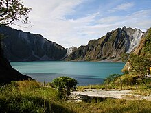
[37] The caldera formed and Lake Pinatubo has, since June 15, 1991, become a tourist attraction with the preferred route through Barangay Santa Juliana in Capas, Tarlac.