Mount Unzen
The period from 400,000 to 300,000 years ago saw the emplacement of large areas of pyroclastic flow and lahar deposits; these form the major part of the volcanic fan surrounding the volcano.
Beginning 300,000 to 150,000 years ago, thick phreatomagmatic deposits were laid down, suggesting the subsidence of the volcano into its graben was rapid during this period.
In the spring of the following year, there was a flood from the Kujuku Island crater, located on the southeastern flank of Fugen-dake at an altitude of 600 metres (2,000 ft).
Eventually, the east flank of the Mayu-yama dome collapsed unexpectedly following a post-eruption earthquake, creating a landslide into Ariake Bay.
In 1975, bird and animal carcasses were found in the surrounding area, and high concentrations of carbon dioxide were detected emitting from rock fractures.
On May 15, the first debris flow caused by accumulated volcanic ash at the summit occurred, and a number of cracks were formed on the west side of the crater, extending in an east–west direction.
A pyroclastic flow triggered by the collapse of a lava dome reached 4.5 km (2.8 mi) from the crater and claimed the lives of 43 scientists and journalists, including volcanologists Katia and Maurice Krafft and Harry Glicken.
In order to capture the pyroclastic flow activity on film, the mass media chose a select spot within the evacuation advisory area.
The fact that pyroclastic flows were being recorded in clear images for the first time attracted a great deal of attention from all over the world, and many volcanologists and government officials entered the evacuation advisory area for interviews and photography.
On May 28, the Ministry of Construction (at that time officials of the Public Works Research Institute) released a picture taken when entering the path of previous pyroclastic flows below the lava dome, and another group on the afternoon of June 1 or 2.
In particular, since June 2 was Sunday, many visitors from other prefectures gathered around the Mizunashi River and observed the pyroclastic flows with binoculars and photographed them with video cameras.
However, on May 26, reporters from the Asahi Shimbun were warned that it was likely for them to be engulfed by the clouds, and in an evacuation recommendation, they were asked to leave the "fixed point" and find another area.
According to a photographer who continued aerial photography of the lava dome from the helicopter, "The bottom fans out from the Sabo dam of the Mizunashi River, and if a large pyroclastic flow occurs, there is a strong possibility of it striking the 'fixed point'."
The Asahi Shimbun abandoned their position and retreated past the Tsutsuno bus stop, to instead set up a point in Fukae Town outside the evacuation zone on May 28, and switched to 24-hour shooting from there.
At 4:08 pm, the second large pyroclastic flow occurred, descending the Mizunashi River Valley and reaching 3.2 km (2.0 mi) to the east from the lava dome.
At the "fixed point", members of the media initially left their chartered taxis and company cars on the road with their engine running, facing south so that they could escape immediately in case of an unforeseen event.
As a result, 16 members of the media (including part-time students), three volcanologists (the Kraffts and Harry Glicken), 12 firefighters who were on guard, four taxi drivers, two police officers who came by police car to conduct evacuation guidance, two workers who were removing the city council election poster bulletin board, and four residents who were working in agriculture were killed.
The camera melted due to the high temperature generated by the pyroclastic flow and was severely damaged, but the tape it contained was playable, despite having been buried under volcanic deposits for almost 15 years.
[citation needed] According to the 2011 documentary Face au Volcan Tueur (French for Facing the Killer Volcano), the unexpected surge could have been caused by phreatic explosions as the main body of the pyroclastic flow proceeded down two waterfalls at the headwaters of the river, fragmenting the ash-particles of the avalanche and expanding the energy of the overlaying gas and ash cloud.
Many of the recovered bodies were carbonized due to the extreme heat of the surge, and were identified by either dental records, or personal belongings they carried with them (e.g. wristwatches or cameras).
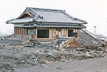
[7] The collapse of the lava dome itself left a notable scar on the eastern side of the summit, and the pyroclastic flow and surge resulted in much damage in the Kamikoba district.
[28] In contrast, the surge that detached from the flow left deposits of ash between 3 and 30 centimetres (1.2 and 11.8 in) thick, however trees were flattened and many buildings continued burning until the next morning.
Twenty-five days after the event, the Japan Meteorological Agency revealed that while the first dome collapse was reported, much of the mass media and local residents were in a state of confusion about the danger of pyroclastic flows, and were not particularly concerned about them overall.
The media originally reported that the pyroclastic flows seen on Fugen-dake at the time were "geologically small", which many regarded as "a scale that would cause no human fatalities".
On May 26, a construction worker operating a Sabo dam in the upstream area of the Mizunashi River was caught in a pyroclastic flow; he survived but was sent to hospital with burns on his arms.
In the Kamikoba area, in particular, there were many farmers who made a living by cultivating tobacco leaf, but since they had been forced to evacuate for a long time (since the May 15 debris flows), their work grew stagnant and many of them were concerned.
The main flow initially descended on the NE flank and was then deflected by Taruki height, directing it to the SE, after which it passed through the already ravaged Kita-Kamikoba, where it remobilized debris from the June 3 eruption, then continued east through the Mizunashi river valley.
In areas other than Shimabara and Fukae, there was ash fall depending on the wind direction, and at Kumamoto Airport, it had an impact on the arrival and departure of aircraft.
Dikes have been constructed in several river valleys to channel lahar flows away from vulnerable areas, and warning systems and evacuation plans have been developed and deployed.
In 1999, an ambitious project began at Mount Unzen to drill deep inside the volcano and sample magma in the 1990–1995 eruption conduit.