Mount Taranaki
"[10] It was also named Pukehaupapa ("ice mountain") and Pukeonaki ("hill of Naki") by iwi who lived in the region in "ancient times".
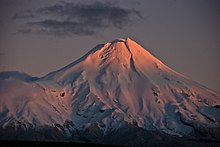
Cook described it as "of a prodigious height and its top cover'd with everlasting snow," surrounded by a "flat country ... which afforded a very good aspect, being clothed with wood and verdure".
[14] When the French explorer Marc-Joseph Marion du Fresne saw the mountain on 25 March 1772 he named it Pic Mascarin.
The vast volume of material involved in these collapses is reflected in the extensive ring plain[30] surrounding the volcano.
[25]: 466 A volcanic event is not necessary for a lahar: even earthquakes combined with heavy rain or snow could dislodge vast quantities of unstable layers resting on steep slopes.
Research from Massey University indicates that significant seismic activity from the local faults is likely again in the next 50 years and such might be permissive to an eruption.
[25]: 473 Prevailing winds would probably blow ash east, covering much of the North Island, and disrupting air routes, power transmission lines and local water supplies.
[32] The oldest volcanic remnants consist of a series of lava plugs: Paritutu Rock (156 metres), which forms part of New Plymouth's harbour, and the Sugar Loaf Islands close offshore.
[25]: 459 Much of Pouakai's large ring plain was obliterated by the Egmont Volcano, the hills near Eltham being the only remnant to the south.
[b] Tongariro eventually won the day,[37] inflicted great wounds on the side of Taranaki, and causing him to flee.
[3] In 1839 the mountain was climbed by James Heberley, a whaler who reached the summit first and the Swiss trained doctor and naturalist Ernst Dieffenbach.
[39][not specific enough to verify] Dieffenbach was employed by the New Zealand Company to advise on the potential of land he explored in the North Island in 1839–40.
The legislation was framed with the intention of seizing and dividing up the land of Māori "in rebellion" and providing it as farmland for military settlers.
[40] The Waitangi Tribunal, in its 1996 report, Kaupapa Tuatahi,[41] observed: "We are unaware of the evidence that the hapū agreed to this arrangement.
It cited a submission that suggested the political climate of 1975 was such that the board felt it was necessary to perform a gesture of goodwill designed to create a more favourable environment within which a monetary settlement could be negotiated.
[46] With intensively-farmed dairy pasture right up to the park boundary, the change in vegetation is sharply delineated as a circular shape in satellite images.
The Taranaki Alpine Club maintains Tahurangi Lodge on the north slope of the mountain, next to the television tower.
[44] The highest access road reaches the East Egmont plateau, with a viewing platform and parking facilities for the skifield.
There are park visitor centres at North Egmont and at the waterfall Te Rere o Kapuni on the southeast side.
The first transmitter at the site was commissioned by the New Zealand Broadcasting Corporation (NZBC) in 1966 to relay Wellington's WNTV1 channel (now part of TVNZ 1).