Muar (town)
It is one of the most popular[1] tourist attractions in Malaysia to be visited and explored for its food, coffee and historical prewar buildings.
However, both divided administrative districts are still collectively and fondly called and referred to as the region or area of Muar as a whole by their residents and outsiders.
Historically, Muar was also where the deposed heir of the Malacca Sultanate escaped to in 1511 following the Portuguese invasion launched from Goa by Afonso de Albuquerque.
Muar played a role in resisting the Portuguese occupation of Malacca; the Kubu Bentayan fort was built by Sultan Mahmud Shah to repel seaborne invasions, before he was defeated and retreated further to Pagoh, this time witnessing the fall of his empire.
A civil war between the prince of Sultan Hussein Shah; Tengku Ali dan Dato' Temenggong Daeng Ibrahim which was later settled by a treaty of agreement and understanding signed in Singapore between the British and Tengku Ali; that ceded the control of the rest of state of Johor (except Muar region) formally to Temenggong Ibrahim in returns of the sultan title with the condition the title is not hereditary for succession, and recognition of him as Sultan Ali and his reign ruled over the Muar region (state) of the area lies between the Muar River and Kesang River with an annual pension from the British Government under the terms of the treaty.
However, Sultan Ali found himself unable to pay settle his debts in time, and an angry Shellapah wrote to the British government in 1866.
[14] His relations with Temenggong Daeng Ibrahim remained strained; in 1860, Sultan Ali allowed a Bugis adventurer, Suliwatang, the chiefs of Rembau and Sungei Ujong to settle in Muar and prepare themselves for an attack on Johor.
During the 1880s, the sovereign rulers of Johor, Temenggong Ibrahim and his successor, Sultan Abu Bakar introduced the Kangchu system and actively encouraged the Chinese leaders to set up new gambier and black pepper plantations and to bring in the Chinese immigrants as agricultural settlers and labourers to open and work in these plantations in Muar.
The Temenggong quickly established goodwill relations with the Kapitan Cina by appointing one Malay administrator, Muhamad Salleh bin Perang, the Dato' Bentara Luar who was able to speak the Teochew dialect, the language spoken by most Kapitan Cina and settlers and able to read Chinese for these purposes.
Modern Muar Town, known as Bandar Maharani, which is the main city center of Muar district, was founded by Dato' Bentara Luar, Muhamad Salleh bin Perang in 1885 and was only officially opened by His Majesty Maharaja Abu Bakar 12 August 1887 (who just became opted Maharaja title on 30 June 1868) and conferred the namesake Bandar Maharani meaning the Town of Empress, the title of Maharani Fatimah who had accompanied to graced the inauguration ceremony of the new town at Tangga Batu a place around Hentian Maharani bus station now where an auspicious "amulet" or "azimat" is said to be buried underground there then.
[19] The prosperity and rapid development of Muar made it the only town in Malaysia ever to have had its own local railway network in the early days.
The Muar State Railway (MSR) operated from 1889 to 1925, linking Jalan Sulaiman in Bandar Maharani and Sungai Pulai for a distance of 22.5 km.
A 1916 plan to extend the line to Batu Pahat was aborted and the service totally stopped in 1925 due to financial and geographical constraints and its reduced importance after the construction of Jalan Abdul Rahman linking the Muar town and Parit Jawa.
It remains a memory and is only a part of history of Muar now with just the MSR steam locomotive relic on display at Tanjung Emas Park.
During the 1942–45 Japanese occupation of Malaya era, Muar continued to serve as important administration town under the occupying Japanese army with many locals involved in the bulk of anti-Japanese resistance groups such as the Malayan People's Anti-Japanese Army (MPAJA) and Force 136.
Muar also recorded the history of resistance against the communist attacks and British occupation by Panglima Kiyai Salleh, a religious and martial arts teacher of Banjarese & Javanese origin who founded the resistance guerillas troop Tentera Selempang Merah.
The Group of Seven or Orang Tujuh of Muar which consists of Tun Dr Awang Hassan (the former Governor of Penang), father of Tun Dr Ismail Dato Abdul Rahman Mohd Yasin (father of Tun Dr Ismail former Deputy Prime Minister), his brother Datuk Sulaiman Abdul Rahman, Tan Sri Datuk Hassan (former Menteri Besar) and Dato Hj Kosai Mohd Salleh was said to be active fighting the formation of Malayan Union and advocating the independence of Malaya.
Muar, like the rest of peninsular Malaysia, enjoys a year-round equatorial climate which is warm and sunny, along with plentiful rainfall, especially during the southwest monsoon from April to September.
The highway that traverses through the outskirts of the town has ease the journey by diverting the traffic from downtown Muar.
Train services to the state capital Johor Bahru as well as Kuala Lumpur, Ipoh, Seremban or Tumpat in Kelantan are available.
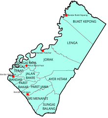
[citation needed] Industrial estates within Muar district are located at Tanjung Agas, Bukit Bakri, Jorak, Parit Bakar, Pagoh and Tangkak.
There are notably three big factories of multinational companies, i.e. STMicroelectronics, Micron Technology and Pioneer Corporation at Tanjung Agas.
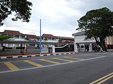
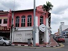
The town is robust of business and trading activities, with many old traditional Chinese shops offering variety of products at reasonable and attractive prices.
[citation needed] There are many cafes that are being open in Muar around the Bakri area to attract tourists and for local enjoyment.
Its alumni include national and state leaders, high-ranking government officials and industrialists, such as Osman Saat, Muhyiddin Yassin, Abdul Ghani Othman, Bahar Munip, and Hussin Hj Ismail.
The dancers usually perform in pairs and are accompanied by a traditional music ensemble normally consists of the gambus, accordion, violin, marwas (bongos), rebana (drum) and dok.