Munich gravel plain
These most recent deposits overlie the Neogene Molasse basin of the Alpine Foreland, which in contrast comprises fine-grained fluviatile and lacustrine facies.
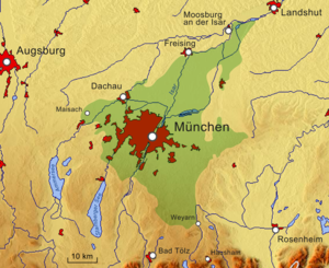
The three corners corresponded with the town of Weyarn, between Miesbach and Holzkirchen in the southeast, Moosburg an der Isar in the northeast and Maisach in the west.
[4] All these ice age gravel deposits lie on top of the low hydraulic conductive sediments of the Molasse basin.
The basin's sediment material of conglomerates, shales and debris have accumulated by erosion and denudation and formed in a sequence during the development of the Alps between around 50 to 3 million years ago.
Further natural waters are the Hachinger Bach and the Gröbenbach and its tributaries, which all, due to exudation of groundwater, rise on the Munich gravel plain.
To prevent future flooding, a drainage ditch was built in the early 1920s, which caused the groundwater table to drop significantly, which in turn required deeper wells to be dug in these communities.
People settled around the local wells and the settlements were named after the owners of these precious water sources, such as Putzbrunn (once Puzzoprunnin after a Puzzo) or Grasbrunn (Gramasprunnin after a Gramas or Graman).
Most of the defunct sand and gravel pits have undergone years of extensive recultivation and have since become popular recreation sites for the inhabitants of metropolitan Munich.