Murray River
From an east–west direction it turns south at Morgan for its final 315 km (196 mi), reaching the eastern edge of Lake Alexandrina, which fluctuates in salinity.
[6] The border between Victoria and New South Wales (NSW) lies along the top of the southern or left bank of the Murray River.
The Murray carries only a small fraction of the water of comparably sized rivers in other parts of the world, and with great annual variability of its flow.
The Murray is the border between New South Wales and Victoria – specifically at the top of the left bank (i.e. the Victorian side of the river).
For 11 km (6.8 mi) west of the line of longitude 141°E,[note 2] the border is between Victoria and South Australia, in the middle of the river.
[10] The discrepancy was caused during the 1840s, when the border was originally surveyed, by an east–west miscalculation of 3.72 kilometres (2.31 miles), and led to a long-running boundary dispute.
This includes native fish such as the famous Murray cod, trout cod, golden perch, Macquarie perch, silver perch, eel-tailed catfish, Australian smelt and western carp gudgeon, as well as other aquatic species such as the Murray short-necked turtle, broad-clawed yabbies and the large-clawed Macrobrachium shrimp, in addition to aquatic species more widely distributed through Southeastern Australia such as common long-necked turtles, common yabbies, the small claw-less paratya shrimp, water rats and platypus.
Extreme droughts between 2000 and 2007 put significant stress on river red gum forests, leading to mounting concern over their long-term survival.
Thus the displacement of the Cadell Fault 25,000 BP led directly to the formation of the famous Barmah River Red Gum Forests.
The Murray has not had enough flow power to naturally enlarge The Barmah Choke and The Narrows to increase the amount of water they can carry.
The Cadell Fault is quite noticeable as a continuous, low, earthen embankment as one drives into Barmah from the west, although to the untrained eye it may appear man-made.
Since the early 2000s, dredging machines have operated at the Murray Mouth for 24 hours a day, moving sand from the channel to maintain a minimal flow from the sea and into the Coorong's lagoon system.
Without the dredging, the mouth would silt up and close, cutting the supply of fresh sea-water into the Coorong National Park, which would then warm up, stagnate and die.
Being one of the major river systems on one of the driest continents on Earth, the Murray has significant cultural relevance to Aboriginal Australians.
Ngurunderi pursued the fish (who, like many totem animals in Aboriginal myths, is often portrayed as a man) on rafts (or lala) made from red gums and continually launched spears at his target.
The Wotojobaluk people of Victoria tell of Totyerguil from the area now known as Swan Hill, who ran out of spears while chasing Otchtout the cod.
Hawker is known to have sold his share in the Bungaree Station, which he founded with his brothers, and relocated alongside the Murray at a site near Moorundie.
[29] In 1852, Francis Cadell, in preparation for the launch of his steamer service, explored the river in a canvas boat, travelling 1,300 miles (2,100 km) downstream from Swan Hill.
Included in the township were "Jane Street", named in honour of Carlyle's wife Jane Carlyle and "Stuart-Mill Street" in honour of political philosopher John Stuart Mill[31] In 1858, the Government Zoologist, William Blandowski, together with Gerard Krefft, explored the lower reaches of the Murray and Darling rivers, compiling a list of birds and mammals.
George "Chinese" Morrison, then aged 18, navigated the river by canoe from Wodonga to its mouth, in 65 days, completing the 1,555-mile (2,503 km) journey in January 1881.
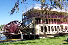
However, in the 19th century the river supported a substantial commercial trade using shallow-draft paddle steamers, the first trips being made by two boats from South Australia on the spring flood of 1853.
The vessel was based at Murray Bridge, and operated between Goolwa and the Victorian border, stopping at towns such as Mannum, Morgan and Renmark as well as isolated settlements and workcamps.
[40] The Murray was plagued by "snags", fallen trees submerged in the water, and considerable efforts were made to clear the river of these threats to shipping by using barges equipped with steam-driven winches.
In recent times, efforts have been made to restore many of these snags by placing dead gum trees back into the river.
The primary purpose of this is to provide habitat for fish species whose breeding grounds and shelter were eradicated by the removal of the snags.
Brady chronicled an eventful journey downriver in a small motor boat from Albury to the coast in 1911 in River Rovers.
These were originally proposed to support navigation even in times of low water, but riverborne transport was already declining due to improved highway and railway systems.
The most pernicious are carp, which have contributed to environmental degradation of the Murray and its tributaries by destroying aquatic plants and permanently raising turbidity.
From 1935 to 1940 a series of barrages was built near the Murray Mouth to stop seawater entering the lower part of the river during low flow periods.
These dams inverted the patterns of the river's natural flow from the original winter-spring flood and summer-autumn dry to the present low level through winter and higher during summer.