Hindmarsh Island
Hindmarsh Island is 100.1 kilometres (62.2 miles) south east of the Adelaide city centre, around a 1-hour and 15 minute drive.
Prior to European colonisation, the island was occupied by Ngarrindjeri peoples, who know it as Kumarangk.
[1][2] 1830: The first European to set foot on Hindmarsh Island was Captain Charles Sturt.
1857: A signal mast was erected at Barker Knoll to convey safe passage condition messages to vessels wishing to pass through the mouth.
In the same year the first inter colonial telegraph line passed through the island to link Adelaide with Melbourne.
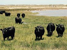
1868: Hereford cattle and Shropshire sheep arrived in South Australia, when Charles Price introduced them onto the island.
1935: Construction of the permanent barrages took place with the aim of maintaining a consistent water level around the river Port of Goolwa and keeping salt water away from the northern shore, improving agricultural opportunities.
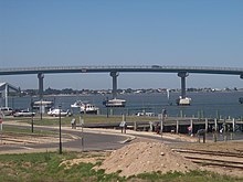
The bridge became a focus of national controversy when a group of local Indigenous people (the Ngarrindjeri) and some landowners objected to its construction.
It was alleged that the Ngarrindjeri objectors fabricated the cultural significance of the island (the "Secret Women's Business") in order to help fight the development.
Upon the evidence before this Court I am not satisfied that the restricted women's knowledge was fabricated or that it was not part of genuine Aboriginal tradition".
[6]: para 317 Area: 45.5 square kilometres (17.6 square miles) Coastline: 43.7 kilometres (27.2 miles) (not including marina) Highest Elevation: 25 metres (82 feet) (35°30'30.28"S 138°49'21.83"E) Salt Lakes Total: 49 Terrain: grassland, wooded forest, salt lakes and mangroves Mundoo Island (35°33'4.35"S 138°55'0.86"E) is a medium-sized island off the east coast of the island.
The road acts also as a barrage to prevent the river water flowing through Murray Mouth into the ocean.
Limestone Island can be viewed very easily from Goolwa north because it is only 700 metres (2,300 feet) away.
Area: 15 hectares (37 acres) Perimeter: 1,755 metres (5,758 feet) Distance from Hindmarsh Island: 961 metres (3,153 feet) Akin to Adelaide, Hindmarsh Island experiences a typical Mediterranean climate with hot, dry summers, and mild cool winters.
Height: 3.4 metres (11 feet) The Hindmarsh Island Airstrip ( 35°30'19.92"S 138°51'2.48"E) was developed in the 2008, for emergency aircraft landings like the Flying Doctor Service and the Private Cessnas, the runway is hardened dirt.
It is located the centre of a dried up salt lake, that does become full of water in winter.
Area: 7.7 hectares (19 acres) Length: 410 metres (1,350 feet) Lowest Point: −2 metres (−6.6 feet) (below sea level) Narnu Farm (35°30'18.17"S 138°49'50.40"E) is a family friendly holiday destination & tourist attraction located on Hindmarsh Island, the farm full of animals & an accommodation experience.
It covers 8.1 hectares (20 acres) of land, and which a majority of that space is a part of Alberto Forest.
Today the cemetery is a popular attraction, some of the birth dates ranging from the late 1700s to the mid-1900s.
Ukrainian Youth Association Camp Ground (35°30'37.65"S 138°49'26.74"E) is a campground that is located on Randell Road.
Perimeter: 6.89 kilometres (4.28 miles) Area: 1.48 square kilometres (0.57 square miles) Selberto Forest (35°30'28.00"S, 138°54'28.43"E) is located on the east side of the island, the Forest mainly collides with residents properties.
Perimeter: 10.1 kilometres (6.3 miles) Area: 5.2 square kilometres (2.0 square miles) A wide range of biodiversity inhabits Hindmarsh Island, below is a list of animals that live on Hindmarsh Island.
This marsupial is mainly found in the forest and open grassland areas of Hindmarsh Island.
These skinks feed on a wide variety of insects, land snails, flowers, fruits and berries.
The Australian magpie (Gymnorhina tibicen) is a medium-sized black and white bird native to Australia.
The Red Fox is an extremely shy animal, and will avoid humans when confronted.
Hindmarsh Island either contains or is within the boundaries of the following areas designated for protection and similar purposes.
[9][10] The Ramsar site known as the Coorong and Lakes Alexandrina and Albert Wetland includes the full extent of the island and its adjoining waters.